Category: Soils

  • Native Plant Seeding Solutions for High Disturbance Highway Roadsides

    Native Plant Seeding Solutions for High Disturbance Highway Roadsides

    By Wes Bollinger

    Wes Bollinger completed his master’s in 2025 with Jeffrey Matthews lab in the Department of Natural Resources and Environmental Sciences at the University of Illinois. Wes is now a restoration ecologist in Chicago and runs his own restoration consulting business – Wildshape Ecological Design.

    The modern American landscape is crosscut by millions of miles of roadways. This land that was previously part of intact ecosystems has been converted into impermeable pavement and ditches, reducing the quantity and quality of habitat. Roadways also lead to habitat fragments, which can impede the movement of animals around the landscape. Highways in the Midwest (Illinois, Indiana, Iowa, Michigan, Minnesota, Missouri, Ohio, and Wisconsin) amount to more than 100,000 centerline miles (160,934 km) of roadway, and their unpaved right-of-way (roadside margins, medians, interchanges, etc.) total over 1,010,000 acres (445,000 ha) of unpaved land and soil. Highway roadsides typically experience high rates of disturbance due to wind, vehicle traffic and pollution from oil, microplastics from tires and litter, and often agricultural additives like herbicides, insecticides, and fertilizers. These lands and similar areas adjacent to roadways may be either burden or boon to the local ecosystem depending on management regimes and use of disturbance tolerant plant species. Here I recommend an approach to identifying appropriate native species for roadside vegetation, but this perspective may also apply to a variety of marginal greenspaces, such as residential sidewalk strips.

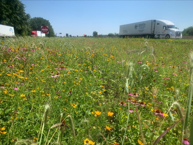
    Native species dominated restoration project on a highway roadside in Northern Illinois. Visible flowerheads are pale purple coneflower (Echinacea pallida), lanceleaf coreopsis (Coreopsis lanceolata), black-eyed Susan (Rudbeckia hirta), and Canada wildrye (Elymus canadensis). Photo by Wes Bollinger.

    If poorly managed, rights-of-way can become heavily invaded by nonnative plants like common reed (Phragmites australis), teasel (Dipsacus fullonumDipsacus laciniatus), and Johnsongrass (Sorghum halepense) among many others. These invasive species inhibit the native grasses and forbs and reduce ecosystem functioning. When heavily invaded, roadsides also cause economic impacts, functioning as source populations of weeds that can impact adjacent agroecosystems. Typically, roadsides are seeded with a mixture of Eurasian turfgrasses like Kentucky bluegrass (Poa pratensis) and red fescue (Festuca rubra). These nonnative grasses are comparatively short both in their above- and below-ground growth. Their short roots do not inhibit the growth of undesirable nonnative species, resulting in more mowing and maintenance than a native plant community to keep areas appearing ‘pristine.’ 

    However, roadsides can be restored with native species and managed using best practices to provide economic and environmental benefits to the region. Native-dominated vegetation can inhibit invasion, protect nearby remnant habitats, promote healthy soil, improve stormwater retention, absorb agricultural additives, sequester carbon, and provide forage and migration corridors for native animals. Though establishing native vegetation on roadsides may have these obvious benefits, there are many knowledge gaps pertaining to this practice such as how and what to seed in these areas to maintain the highest ecosystem fidelity and greatest economic benefits.

    We conducted research to determine which native species to seed on highways and the best practices for establishment and maintenance of these areas, with the goals of lowering overall maintenance costs by reducing the frequency of mowing needed to maintain these areas. This work was funded through grants from the Illinois and Indiana Departments of Transportation (DOTs) in conjunction with the Illinois Center for Transportation and the University of Illinois.

    I carried out three projects to gain empirical evidence on how to restore Midwestern roadsides with native species. Project 1) reviewed the native seeding practices of the DOTs of the Midwest to identify commonly seeded species and assessed establishment and management practices. For Project 2) we conducted experimental trials in Illinois comparing existing Illinois DOT mixes (non-native and partially native) with novel mixes that we designed to be more diverse and contain only native species. For Project 3) we conducted a field survey of existing native roadside plantings across Illinois and Indiana. Projects 2 and 3 sought to quantify the performance of individual species to determine which ones have the greatest establishment and persistence in roadside conditions, and what conditions lead to favorable native establishment generally.

    Project 1) Current native seeding and management practices

    My review of Midwestern DOT seeding practices revealed stark differences between DOTs among states, but some commonalities that are noteworthy for establishment and maintenance. Most interestingly was the disparity in native diversity between states. Michigan did not list any native species in their roadside manual, while Minnesota listed 108, the most of any Midwestern DOT. Further, Minnesota listed 11 majority or entirely native seed mixes and had the most comprehensive standard operating procedures for native seeding. Many mixes had average max heights under 3 ft (~1m) to avoid obscuring motorists views on roadsides; however, some states had mixes more than 5 ft (~1.5 m) for tallgrass areas and to increase the invasion resistance of an area by blocking light access with taller plants. Perhaps surprisingly, the states of Ohio and Indiana still list an invasive legume, crownvetch (Securigera varia), in mixes designed for erosion control.

    Number of majority native species mixes listed by Midwestern Department of Transportation in order of most to least native species (n) listed.

    Several establishment methods were common across states. Native seeds should be sown into low-fertility topsoil using a hydroseeding machine (a device that sprays a mixture of seed, water, and an organic adhesive agent directly onto soil) especially on sloped areas. Hydroseeders show remarkable success in soils with a seed bank containing invasive species, by avoiding tillage which can bring these seeds to the surface and increase their germination. Native straw can be applied as a mulch layer and may be harvested from areas scheduled for maintenance with mowing. Seeding should take place in the fall to allow for cold stratification. Local ecotype seeds are preferred to produce individuals with locally adapted phenotypes and avoid genetic contamination with seeds harvested outside the region. Mowing in the first year of growth is critical to reduce invasive species while native seedlings establish. Minnesota recommends three mows in year one, in May, June, and July, and a singular mow between July and August of year two. Controlled burning of these areas is ideal every 3-5 years but mowing at the same rate is also beneficial. 

    Project 2) Comparative performance of standard (mixed origin) and native-only mixes

    As a method of direct comparison between existing DOT seed mixes and a fully native roadside, I established four trials across Illinois to test differences in seeded, native, seeded native, and nonnative unseeded plant cover and richness, thus also providing information on invasion resistance between four popular mixes (DOT lawn, roadside, north IL, south IL) and four corresponding fully native plant mixes I designed to meet the same general criteria (low growing, disturbance, and salt tolerant) while also being higher diversity (from 9 to 38 species depending on mix). These experimental plots were seeded in November 2023 and surveyed in May and August of 2024. I observed that plantings differed in degrees of success, but every trial showed at least one significant positive result for the native planting over the nonnative IDOT mix. Native richness was higher for all sites by August of the first growing year, and native cover was higher for three of the four experiments. My trial of the IDOT Class 3 North Slope mix against a mix of 38 native species yielded significantly higher seeded cover by August 2024, and higher richness and cover of all native species in both May and August, suggesting that this high diversity mix competed very well against an existing DOT mix which was a combination of native forbs and nonnative grasses. Based on preliminary data collected during 2025, the native species are continuing to outpace the nonnatives in these mixes. 

    Of the native species seeded in these trials, those with the greatest record of germination in year one are lanceleaf coreopsis (Coreopsis lanceolata), common milkweed (Asclepias syriaca), partridge pea (Chamaecrista fasciculata), Illinois bundleflower (Desmanthus illinoensis), pale purple coneflower (Echinacea pallida), common evening primrose (Oenothera biennis), golden Alexander (Zizia aurea), blue vervain (Verbena stricta), and plains oval sedge (Carex brevior), which were present in the first year between 50% and100% of plots they were seeded in.

    Example paired plot before site prep and seeding (left) and August of the first growth year after establishment (right). IDOT mix on the left, native mix on the right of each image. Yellow flowers are golden Alexanders (Zizia aurea). Photo by Wes Bollinger.

    Project 3) Identifying the most successful native species from field surveys

    Lastly, I surveyed 34 native plantings on roadways across Illinois and Indiana at various distances from the road edge while collecting data on soil chemistry, surrounding land use, and soil compaction. Sites were more than two years old to avoid plantings early in their establishment. The purpose of this project was to identify which seeded species tend to germinate and persist, and what environmental factors contribute to higher native and invasive success. Of the 153 native species seeded in one or more sites, we found that 28 native species were observed in at least half of the planted sites and 84 species were never observed once despite being seeded in anywhere from one to 12 sites. Five species were found a total of 10 or more times each across all 34 sites: common milkweed (Asclepias syriaca), bee-balm (Monarda fistulosa), black-eyed Susan (Rudbeckia hirta), false sunflower (Heliopsis helianthoides), and switchgrass (Panicum virgatum). These five species along with Virginia wildrye (Elymus virginicus) were also the most observed species at sites where they were seeded. These surveys were not designed to be comprehensive given the size of many of these plantings and it is highly probable some other seeded species were present but unobserved.

    I found that native diversity and cover were generally higher further from the road edge, in areas with less salt, more basic soil, lower nitrogen and phosphorous, and a higher seed mix diversity. The opposite was true for nonnative cover and diversity. Richness of the seeded native mix was one of the strongest determinants of both diversity and cover. 

    In summary, we recommend that seed mixes should be hydroseeded at a rate of 60-70 seeds per square ft. (650-750 seeds per square meter) into low-nutrient, unfertilized soils, and covered in native straw. High-diversity mixes with no more than 10% legumes and an otherwise equal ratio of grasses to forbs should be used. Several species (but no more than 10%) should be early-establishing annual forbs for first year cover. Select species so that there is at least one blooming at all times of the growing season, favoring plants like golden Alexander (Zizia aurea) and native Alliumspecies for early spring blooms. Seed in as large an area as possible to reduce edge effects, consider cloverleaf interchanges as ideal locations for large projects.

    For maintenance in year one post-seeding, mow several times (May, June, July, potentially also August in warmer states) to a height of 6-8 inches. In year two, mow at least once between June and September. Controlled burning or mowing can be conducted as needed for persistent weed issues but generally are only required every three to five years. If mowing is needed, areas with low abundance of non-native plants can be harvested as native straw for future plantings.

    Native species with the best establishment record and widest usage are as follows and should be prioritized in high disturbance roadside plantings: Asclepias syriacaAsclepias verticillataBouteloua curtipendulaCarex breviorCarex cristatellaCarex hystericinaChamaecrista fasciculataCoreopsis lanceolataDalea purpureaDesmanthus illinoensisEchinacea purpureaElymus canadensisElymus virginicusEryngium yuccifoliumEupatorium perfoliatumHelianthus grosseserratusHeliopsis helianthoidesJuncus effususMonarda fistulosaOenothera biennisPanicum virgatumPenstemon digitalisPhysostegia virginianaPycnanthemum tenuifoliumRatibida pinnataRudbeckia hirtaSilphium laciniatumSymphyotrichum novae-angliaeSymphyotrichum puniceumLiatris pycnostachyaVerbena strictaVernonia fasciculataand Zizia aurea.

    Further details and methods can be found in the thesis here or by contacting the author at info@wildshaperestoration.com
  • The hidden half of tropical forest recovery 

    The hidden half of tropical forest recovery 

    By Leland Werden

    Leland Werden, PhD, is a Senior Scientist at ETH Zurichlwerden@gmail.com

    I remember starting my PhD in 2012 with a strong desire to develop tools for recovering tropical forests around the world. My background was in ecosystem ecology, which had led me to spend time thinking about soil nutrient cycling and other belowground processes in different temperate forests across the Northeastern United States. What I didn’t realize at the time was that these forests were themselves an incredible regeneration success story.

    As agriculture moved westward to more suitable land between the 1870s and 1920s, New England farmers abandoned their fields and pastures, and forests naturally regenerated at scale. This century of intensive agriculture left a patchwork of land-use legacies that continued to influence forest composition and recovery in fascinating ways. I stumbled into this living laboratory as an undergraduate student at the Harvard Forest Long Term Ecological Research site, measuring forest recovery across this patchwork.

    One patch has stuck in my head since: a grove of the largest striped maples (Acer pensylvanicum) I’ve ever seen. Striped maple is typically an understory shrub that rarely reaches more than six meters (20 feet) tall. But in this tiny patch, about 20 individuals had ascended to the canopy and completely dominated the overstory. In chatting with one of the landscape ecologists on staff over lunch one day about this pattern, I learned that there used to be a farmstead there and the striped maples thrived on the elevated nutrients still present in the soil more than a century after the farm was abandoned.

    Despite having collected hundreds of soil cores in my life, sieved roots out of soil for months on end, and counted tiny soil fauna, I had never fully grasped how strongly soil type and land-use legacy could shape plant communities. That grove of striped maples taught me to look belowground to understand plant composition. Years later, when I began working in tropical forest restoration, some colleagues and I grew to understand that we were missing the same understanding on a large scale — focusing almost entirely on what grows aboveground while largely ignoring what happens beneath our feet when restoring tropical forests.

    This disconnect isn’t unique to tropical restoration. Across forest restoration projects worldwide, we count trees, measure canopy cover, and get excited to see the return of birds and dung beetles. These are important signs of recovery, but soils, roots, and the communities of organisms that live within are often overlooked. These living organisms drive water and nutrient cycling, contribute strongly to climate mitigation capacity, and also to long-term resilience that determine whether restored forests can withstand decades of droughts and other stresses to come.

    The recognition of this blind spot led some worlds to collide. A group of academics passionate about tropical root dynamics (TropiRoot) began to collaborate with multiple research groups working on restoration science across Europe, Latin America, tropical Africa, and the United States. Our core question was: How can resource-limited tropical forest restoration projects measure belowground recovery in a scientifically robust way? In the fall of 2023, my colleague Dr. Laura Toro and I, along with several others, started a working group to tackle this challenge. We met for three days in October of 2023 at the Yale School of the Environment and brainstormed a project that aimed to distill decades of research on soil science into priority indicators that capture the essence of soil recovery. 

    Our belowground restoration group meeting at Yale University and online in October 2023.

    A clear belowground monitoring gap 

    As we dug into global restoration monitoring frameworks and the scientific literature, the scope of this oversight became even clearer. A recent worldwide stocktake catalogued more than 4,500 indicators that restoration projects use to measure “success”. Of the 61 indicators chosen as highest priority, just one focused on belowground processes: soil carbon (Gann et al. 2022). Soil carbon is a notoriously difficult indicator to detect changes in, especially over the short timeframes most projects monitor.

    We then systematically reviewed almost 200 scientific studies on tropical forest restoration. Only 28 — fewer than one in seven — directly compared above and belowground properties at the same sites. Without these paired measurements, it’s really difficult to understand whether the recovering vegetation reflects holistic ecosystem recovery or if it might be masking soils struggling to recover from previous degradation.

    The problem extends beyond academic research. When we surveyed restoration practitioners across 14 Latin American countries, we heard a similar story: projects typically have only resources to evaluate aboveground recovery, and often only for the first few years after planting. This is despite having ambitious goals of restoring entire ecosystem processes and recovering biodiversity (Cole and Werden et al. 2024).The appetite to track recovery holistically is there, but accessible tools and protocols often aren’t, so we developed a short list of six indicators and some rules of thumb for belowground monitoring, lowering the barrier to capture belowground recovery (Toro and Werden et al. 2025). We summarize the indicators below. 

    Six indicators to track belowground recovery 

    The strength of these indicators is their simplicity, paired with the ability to robustly summarize belowground recovery over time. Most indicators can be measured with equipment that can be purchased at a hardware store, or analyzed by a basic agricultural soil lab, and the priority indicators selected all change over timescales that matter for restoration

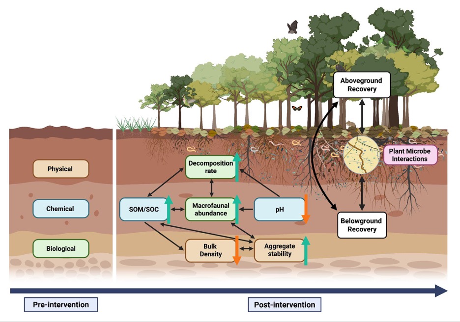
    Physical – 

    • Bulk density tells you how compacted the soil is – or how much soil is packed into a given space. When forests are cleared, machinery and/or grazing animals can compress the soil, making it hard for water to soak in and plant roots to penetrate. We measure this by pushing a metal cylinder of known volume into the soil, drying the sample in an oven, and dividing the dry weight by the cylinder’s volume. High bulk density means compacted soil; low bulk density means less dense, healthy soil with space for air and water that roots can grow into more easily.
    • Aggregate stability captures how well soil particles stick together in clumps, which determines whether rain soaks in or runs off, carrying topsoil with it. In the past, measuring this required laboratory equipment, but now there’s a smartphone app called SLAKES that guides you through the process. You simply just take photos of soil chunks before and after soaking them, and the app calculates an index of how well they held together.

    Chemical – 

    • Soil organic matter is often called the engine of soil fertility — decomposed plant and animal material that holds nutrients and water. It’s what gives soil its color and smell. When land is cleared and intensively used, the organic matter is often burned away or gets washed off. As forests regrow, leaves fall, roots die and decompose, and organic matter slowly builds back up. You can measure it by sending dried soil samples to a lab. 
    • Soil pH can be thought of as a whole bunch of soil chemistry compressed into a single number — it determines which nutrients plants can access. Low pH (acidic soils) can lock up nutrients and sometimes reach toxic levels of aluminum. You can test pH easily in the field by mixing soil with water and using a simple pH meter, or sending a sample to a lab. 

    Biological –  

    • Decomposition rate gives you a window into how active the soil’s living community is, all microbes that break down dead material and release nutrients for plants to use again. We suggest measuring this using “decomposition bags” — mesh bags filled with a standard amount of leaf litter (or even tea bags if available) that get buried in the soil and retrieved after a set time to see how much material decomposed. Faster decomposition usually means a healthier, more active soil community.
    • Macrofauna abundance is the count of larger soil animals such as earthworms, termites, beetle larvae, and others. These soil animals create tunnels that let water and air penetrate, mix organic matter through the soil layers, and their castings can contain  lots of incredibly fertile nutrients. To measure this, you dig a small trench, carefully sort through the soil and litter, and count all the macrofauna you find. It can take time, but these animals can be excellent indicators of soil recovery.
    From Toro and Werden et al. 2025 – Conceptual diagram of the importance of the status of soil properties pre-intervention in tropical forest restoration projects, and the six key dynamic soil indicators we suggest measuring. The black arrows represent known links among soil indicators and between soil properties and above- and belowground recovery processes. The color arrows indicate the expected direction of change: green arrows for increases and orange arrows for decreases. Recovery is also shaped by the reestablishment of plant-microbe interactions, which mediate feedback loops between vegetation and soil processes.

    A simple way to get started

    As part of our paper we also developed some recommendations for practitioners to start implementing belowground monitoring:

    • When to sample: Before restoration begins, set a baseline, then measure every 5 years or more frequently if possible. 
    • Where to sample: The top 10 cm of soil captures most early changes. 
    • How many samples: 5-10 cores per plot usually gives a reliable average. 
    • How to report: Use standard units so your data can be compared across sites and integrated into broader monitoring efforts. 
    • Other measurements: If you already measure above ground recovery indicators, keep doing that. Some aboveground patterns offer clues about what’s happening below, but in many cases, especially for soil carbon or microbial activity, what you see aboveground doesn’t tell the full story.

    Why below recovery matters for restoration

    Understanding soil recovery has immediate practical implications for understanding restoration outcomes. Healthy soils speed up seedling establishment, improve drought resistance, and support robust carbon storage that can make tropical forest restoration a viable natural climate solution. But soil recovery can also help projects make better management decisions in real time.

    If bulk density measurements reveal severe compaction, you could adjust your species selection to favor deep-rooted trees that can help break up hardpan layers. If organic matter is low, you could experiment with compost additions or mulching. But, without measuring this belowground information at the outset and as your project progresses, these management decisions can become educated guesswork.

    An invitation to what’s next

    Through the SNAPP Monitoring Restoration Effectiveness (MoRE) working group, we’re now building a collaborative network that connects researchers with practitioners on the ground. Among other things, our goal is to develop straightforward protocols for monitoring  belowground indicators. These protocols will be tested in real-world conditions and adapted based on feedback from practitioners. We’re also compiling longitudinal data from any tropical restoration project that has measured an indicator of below- or above-ground recovery for a global synthesis that aims to develop best practices for restoration monitoring.  

    If you’re working to refine your tropical soil monitoring practices, or if you just generally want to get involved, we’d love to hear from you. 

    Take our questionnaire on monitoring practices –  Here

    Learn more about our data synthesis –  On our website

    Get in touch with the SNAPP MoRE team –  snapp-more@umn.edu

  • Accurately estimating restoration efficacy across large landscapes and timeframes

    Accurately estimating restoration efficacy across large landscapes and timeframes

    By: Dr. Allison Simler-Williamson

    Note from the editors: This month marks ten years since we started Natural History of Ecological Restoration! During the last decade, we’ve posted 127 times on a wide variety of ecological restoration stories from around the world. At the same time, our global readership has grown from 4,000 viewers in our first full year to more than 14,000 viewers in each of the last five years, with readers coming from 150 countries. At their best, NHER stories illuminate ecological restoration’s natural history, taken in the most inclusive sense to mean stories about the people, places, organisms, institutions, and interactions involved in ecological restoration projects.

    This month’s post by Allison Simler-Williamson (Boise State University) exemplifies this standard. In her post, Dr. Simler-Williamson describes how environmental conditions, land manager decisions, and restoration outcomes interact in complex and confusing ways – and she charts a path forward for better understanding the real-world impacts generated by restoration projects.

    A “randomized” experiment can be a beautiful and powerful tool in restoration ecology. Randomization ensures that an experimental treatment (such as a restoration action) is unrelated to any other environmental factors that might influence the outcome we are measuring (such as plant establishment). When we confidently compare plots that received an herbicide or planting treatment to adjacent “reference” sites, our estimation of restoration effectiveness hinges on this assumption of randomization.

    But, despite their elegance, randomized experiments are labor-intensive and often spatially or temporally constrained, limiting how applicable they may be to new areas or in atypical years. Thus, randomized experiments are increasingly mismatched with widespread ecological degradation and growing needs for restoration. Emerging “big data”, such as the US Geological Survey’s Land Treatment Digital Library, which contains information about more than 65,000 restoration treatments that have occurred on Bureau of Land Management land in the western United States, could help tackle the problem of understanding restoration efficacy across wide spatial and temporal scales.

    When we pivot to using these “observational” datasets, which are opportunistically collected, we incur an important tradeoff. We gain generalizability but lose the power of randomization because (and this likely is not a surprise to anyone working in restoration!) real-world management treatments are almost never applied randomly across large landscapes. Restoration occurs in certain parts of landscapes more than others, due to a mix of ecological need, bureaucratic constraints, and stakeholder decision-making processes.

    Why is this lack of randomization a problem when we want to leverage these kinds of large datasets? In statistics courses, I like to use some of my son’s favorite bathtime toys as an analogy for what can occur. When you pour water into these colorful pipes, the wheels spin, and my son loves to create networks between them. If the pipes are arranged as below (Figure 1A) with water flowing through them, it would be immediately obvious that there is no direct relationship between the wheels “X” and “Y” – they are simply both being spun by the water flowing out of “Z”. However, if I were to obscure the connections between the pipes (Figure 1B) and instead ask you, “Based on your observations, is there a relationship between X and Y?”, you could detect a correlation. Depending on your understanding of the system, you might assume that this link is a direct cause of X on Y, or vice versa.

    Figure 1. Confounding variables (Z) jointly impact a predictor variable (X) and our response (Y), biasing our understanding of the relationship between X and Y.

    This phenomenon is an example of statistical “confounding,” in which a background driver can bias our understanding of the relationship between two other variables. This potential for confounding is a big concern if we would like to estimate the efficacy of restoration treatments that were applied in non-random places or times because it can falsely inflate or shrink apparent effects in our analyses. For instance, if restoration actions (X) are disproportionately applied in dry areas (Figure 2a), and drought stress simultaneously reduces plant establishment (Y) (Figure 2b), the correlations between variables can cause a treatment effect to shrink (even if the treatment works!), if we ignore this lack of randomization in treatment applications.

    Figure 2. Non-random application of restoration treatments in real-world settings, due to ecological, social, and institutional processes, can bias estimation of treatment effectiveness.

    In a 2022 study (Simler-Williamson and Germino 2022), we explored how the ‘non-random’ application of restoration seedings of big sagebrush (Artemisia tridentata) influenced our estimation of treatment effectiveness, using observations of post-fire seedings across the western U.S. in the Land Treatment Digital Library.

    When we used statistical models that assumed these restoration treatments were applied randomly, we found a somewhat counterintuitive result: a negative relationship between sagebrush seeding and sagebrush recovery. However, this statistical illusion emerged because of background relationships in our dataset: restoration seedings (Figure 2; X) tended to occur in hotter, drier, and more degraded places (Z), where plant establishment was already more difficult (Y). In short, restoration actions were disproportionately applied in more “dire” ecological settings, creating the illusion of failure.

    Next, we compared this approach to two sets of statistical methods designed to minimize the effects of confounders (“Z”) on our treatment effect. The first set of approaches required that we include pre-existing data about the hypothesized confounding variables directly into our model. When we accounted for some of these measured drivers of “non-random” seeding application using existing data about soil types, climate conditions, and fire impacts, restoration efficacy shifted from a negative number toward a neutral effect.

    Finally, the last set of approaches instead used repeated observations of sagebrush stands to ‘control for’ confounding variables, by accounting for pre-existing differences between treated and untreated stands before they had been seeded, rather than requiring the direct inclusion of measured variables. Only when measured and many unmeasured differences between treated and untreated sites were accounted for in our analysis, we revealed a positive impact (of ~4-6% in sagebrush cover by 10 years post-fire) of restoration seedings in degraded sagebrush ecosystems.

    The pattern we described in that paper underscores two key needs in restoration science: one social and one statistical. These results suggest that we urgently need better information about the socio-economic drivers determining where and when we apply restoration treatments, which are poorly described. The analyses that incorporated some common ecological drivers of restoration need (e.g., fire impacts, climate variables) only accounted for some of the bias in the effects of restoration seeding. The strong shift to positive impacts of restoration after “unmeasured” sources of bias were considered suggests that there are significant additional unmeasured processes that simultaneously shape where we attempt to restore and where plant populations recover. In the focal sagebrush steppe ecosystems, these may include diverse drivers such as seed availability, bureaucratic constraints, aesthetic considerations, cultural values, land use, and grazing management. Collecting and understanding these variables seems essential to advancing our understanding of restoration effectiveness broadly.

    But no matter how elegant randomized experiments are as a concept, they may not be able to generate estimates of restoration effectiveness at the broad spatial and temporal scales we require to manage rapidly changing ecosystems. As a community, I think we need to be integrating big, opportunistically collected datasets with statistical approaches that recognize the “messiness” of these data and aim to minimize the risk of confounding in treatment effects. Well-estimated treatment effects can improve how we connect restoration resources (such as seeds, time, and funding) with the locations where the ecological benefits may be greatest, both in space and time.

    For more information about Dr. Simler-Williamson’s work, see her lab website or her 2022 paper in Nature Communications.

  • Developing an Expanded Soil Profile methodology for restoring social-ecological relations: A case study of Sunnivue Farm, a biodynamic farm in Southwestern Ontario

    By Katherine Lawless, an associate professor in the Centre for Global Studies at Huron University College in London, Ontario, Canada. Katherine is trained as a critical theorist in the humanities and social sciences. Over the past 5 years, she has been developing a new field of specialization in the environmental humanities focusing on the social dimensions of conservation, restoration and climate change adaptation. Below, she describes a pilot study in her collaborative research project on human-soil relations. klawles@uwo.ca

    In 2019, my research team (including soil scientists, social scientists, artists, and humanists) and I received an Exploration Grant from the Canadian New Frontiers in Research Fund to conduct field research in Yukon, Southern Alberta and Southwestern Ontario with communities who understand soil as a living system rather than an inert object or simple resource. We wanted to know what kinds of solutions to complex social-ecological problems might emerge by reframing soil as a relational medium, and a set of natural and cultural relations that participate in the adaptive development of living systems combining ecological and social dynamics. Here, we take our cue from media theorists (Parikka, 2015), human geographers (Kryzwoszynska and Marchesi, 2020), and Science and Technology Studies scholars (Puig de la Bellacasa, 2015) in thinking of soil as a medium that bridges nature and culture; an object that is shaped by human interaction rather than a given, natural thing; and a network of human and more-than-human actors embedded in a nested series of social and ecological networks (see also Greenhough, 2014). This approach recognizes both the biophysical agency of multiple species and the ways in which humans co-create worlds with their non-human counterparts, from flora and fauna to rocks and water. Naturally, we gravitated toward practitioners and knowledge holders with a close relationship to soil, including regenerative farmers, environmental conservationists, restoration practitioners, and Indigenous communities. This research was delayed by the COVID pandemic; so, we started close to home with a small and willing pilot site: Sunnivue Farm. In what follows, I present an overview of this ongoing study in the spirit of the Ecological Health Network and SER International principles and standards for the practice of ecological restoration (Gann et al., 2019), wherein the Restoration Continuum includes the restoration of agroecosystems. 

    Beginning in 2021, we used this pilot study to develop our transdisciplinary methodology: the Expanded Soil Profile (ESP). The idea was to begin with conventional soil profiles and soil analyses, and build out from there, incorporating layers of social and cultural history across scales and eras through interviews and archival research. We hoped this would allow us to form a clearer picture of the kind of place-based social and ecological dynamics at play in the health and wellbeing of human and non-human members of any self-organizing “multi-species soil care community”. To be clear, we define “soil care community” as a group of individuals with a shared practical and ethical commitment to the ongoing labour and attention required to maintain and repair soils in need of repair, and all those who depend on soils in a given landscape, region or place, so as to live as well as possible with a given subset of the land, water, biodiversity, and resources that comprise our world. The concept of a “multi-species soil care community” recognizes that more-than-human actors share with humans in the care work that has shaped and continues to shape this biophysical world (see Kimmerer 2016 for an example).

    Our overall goal is to better understand the connections among soil health, farm ecosystem health, and the perceived health and wellbeing of the local farming and non-farming community in each study area. More specifically, we aim to show how, in the context of internal and external social and economic pressures, local place-based knowledge can be paired with scientific analysis and historical-archival research to orient and guide efforts to restore and maintain sustainable and desirable relations among social actors and institutions in differing contexts.

    A group of people sitting around a table  Description automatically generated

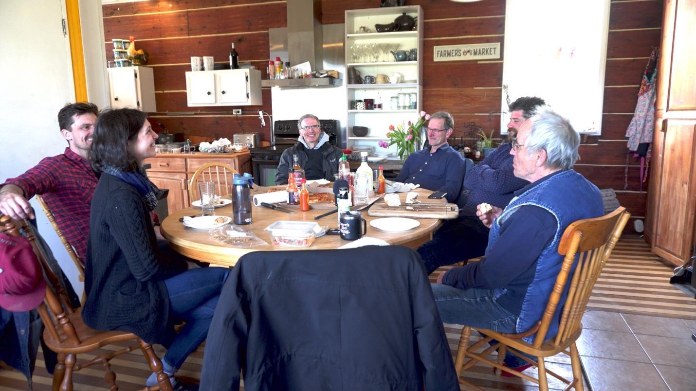
    The core members of the research team and two research participants discussing the project over lunch, Sunnivue Farmhouse, 2021. From left to right: Katherine Lawless (PI), David Janzen (co-PI), Henry Janzen (soil scientist collaborator), Ed Gregorich (soil scientist collaborator), Michael Courey (incoming farmer/research participant), and Alex Nurnberg (retiring farmer/research participant). Photo: Michelle Wilson.

    Sunnivue Farm is a 180-acre biodynamic farm about 22 mi from London, Ontario in the heart of the Carolinian forest, which boasts some of the highest biodiversity in Canada including rare and at risk species. Much of this biodiversity is threatened by urban expansion and agricultural intensification. According to a report issued by the Ecosystem Status and Trends Report (ESTR) Secretariat, “as of 2009, there were 865 species of conservation concern in the [Lake Erie Lowlands] ecozone,” including all 12 reptile and amphibian species, 7 of 8 native turtle species, and 11 of 17 snake species (ESTR Secretariat, 2016, p. 16). And, as the founders of Sunnivue Farm noted in our very first interview, bumblebees are on the decline (ESTR Secretariat, 2016, p. 16). 

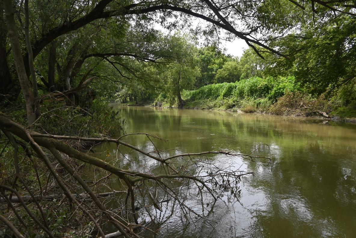
    Sunnivue rests on a Burford soil, a gravelly and cobbly soil formed by glacial-fluvial outwash, or fast-moving glacial meltwaters in a floodplain environment, and the back 20 acres is intact Carolinian forest. The farm is cut through by the Ausable River, a winding waterway flanked on both sides by a three-zone riparian buffer that runs south from West Perth to Ailsa Craig and arcs to the west before emptying into Lake Huron at Port Franks; significantly, it supports “26 species of freshwater mussels and 85 species of fish,” 6 of which are listed by the Committee on the Status of Endangered Wildlife in Canada (COSEWIC) as endangered, threatened, or of special concern (DFO, 2020, p. iii). Many of the key threats to these species—such as build up of sediments due to erosion following the loss of riparian cover, nutrient enrichment (due to tile drainage), contaminants (including pesticide and manure runoff), and habitat modification and landscape fragmentation (due to intensive land use and continuous cultivation)—are linked to the high levels of intensive agricultural practices introduced in the 1850s and that continue still today to dominate the watershed (DFO, 2020, p. iii). 

    A river with trees and bushes  Description automatically generated

    The Upper Ausable River running through Sunnivue Farm, 2023. Photo: Kate Lawless.

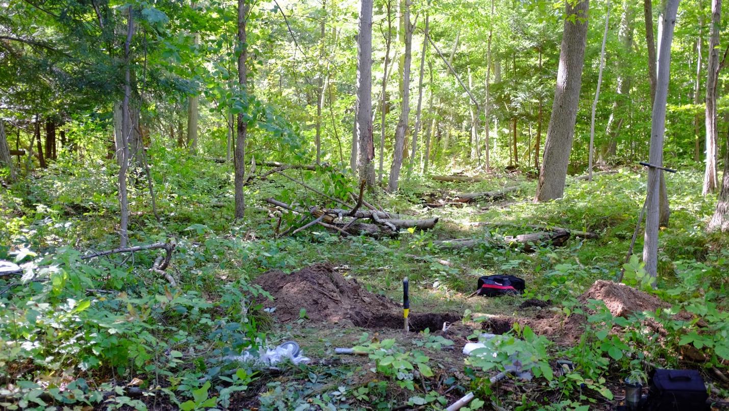
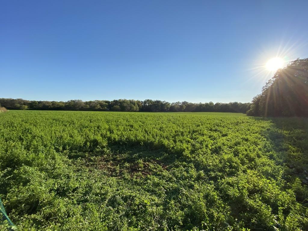
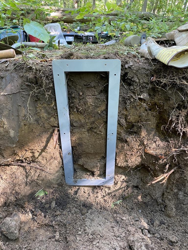
    We began field research in the summer of 2021 with in-depth oral history interviews with five key informants: Alex and Ellinor Nurnberg (the primary farmers from 1991-2021, and founding members of ROSE, a Land Care Association, the not-for-profit trust governing Sunnivue farm), Kristina and Michael Courey (the new farmers as of July 2021 and founders of the social enterprise, New Moon Community Homestead, now operating at Sunnivue) and Jens Stickling (a long-time member and then-chair of the ROSE Board of Directors). We followed these interviews by extracting soil monoliths and samples from two representative sites on the farm, one cultivated and the other uncultivated. The uncultivated site, located in a patch of forest in the back 20 acres, provided a benchmark for the cultivated site, an arable field (previously the market garden) hosting an alfalfa cover crop that has since been reconverted into a market garden. 

    A forest with trees and bushes  Description automatically generated Soil pit in uncultivated Carolinian forest soil, Sunnivue Farm, 2021. Photo: Ed Gregorich.
    A green field with trees and the sun  Description automatically generated

    Site of the soil pit in cultivated soil with a temporary alfalfa cover crop, Sunnivue Farm, 2021. Photo: Ed Gregorich.
    A metal frame on a dirt surface  Description automatically generated

    Extracting the forest soil monolith, Sunnivue Farm, 2021. Photo: Kate Lawless.

    From here, we began historical and archival research starting with Sunnivue Farm and ROSE: Celebrating 21 Years of Building a Dream, 1992-2013, a retrospective containing (among other things) a collection of annual newsletters written by Alex. We continued with visits to local archives and extended periods of participant observation, including a 3-day Vision Retreat in September 2021 to discuss the farm-level vision during the transition between incoming and outgoing farmers. We are continuing this background research by following threads in the interviews that lead us to broader systems-level interactions. We are especially interested in how the farmers and greater community understand their relations with non-humans on the farm, as well as how they speak about the relationship between natural and social systems and their decline or flourishing. Our aim through this process is to elucidate how local human-soil relations are shaped by the often-divergent pressures of both intimate social spheres (i.e., kinship networks) and more-or-less abstract global structures (i.e., international trade networks), and how multi-species soil care communities, or complex networks of diverse lifeforms, negotiate “ecological livelihoods”–or interdependent “habitats” of making, receiving, and providing (Miller & Gibson-Graham, 2020)–in this context. Importantly, the concept of “ecological livelihoods” refuses a clear distinction between Economy and Environment, instead recognizing the “myriad interdependencies in which our sustenance is implicated” (Miller & Gibson-Graham, 2020).

    The results of our research are preliminary but show high levels of soil health despite community perceptions of the overall decline of farm-level ecosystem health. Surprisingly, from a soil science perspective, the health of the cultivated soil (approximated here by measures of soil nutrient levels, soil organic carbon, and microbial respiration and biomass) surpasses that of the uncultivated soil in the forest on the same farm holding. While magnesium and potassium levels are comparable in both soils, phosphorus levels are much higher in the cultivated soil, which indicates good management of inputs. In addition, the total mass of soil organic carbon (which gives an estimate of the health and fertility of the soil) is roughly 40% higher in the cultivated soil (10.9 kg/m2) compared to the uncultivated soil (6.12 kg/m2) which, according to Ed Gregorich, our collaborating soil biochemist, is quite unusual. Alex and Ellinor attribute this to the incorporation of alfalfa in the rotation and the use of composted manure. In addition, the respiratory quotient of the arable soil is larger than that of the forest soil, indicating higher carbon cycling and nutrient cycling by soil microbiota.  

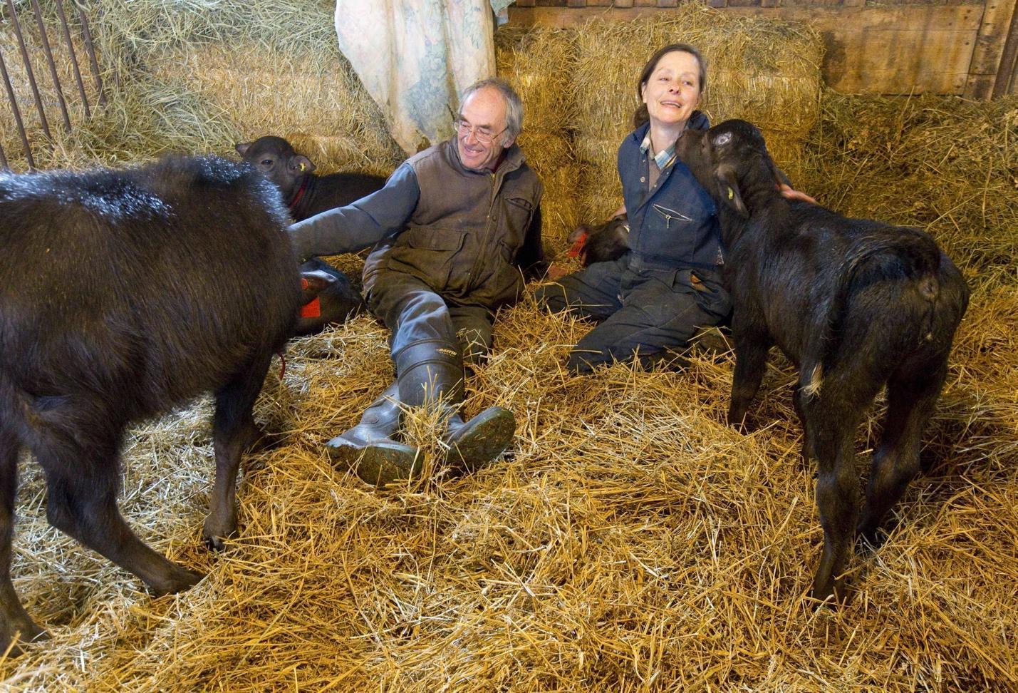
    By contrast, our qualitative analysis shows a shared perception of soil and social “crises” and farm “dis-ease” among the community members, a perception in part linked to declines in biodiversity observed by Alex and Ellinor, a worrying trend that they connect to changes in land use management. These changes were precipitated by external economic pressures, especially proposed changes to the milk quota in 2008. In response, Alex and Ellinor sold their dairy herd. Of course, this was a difficult decision for them since cows are a central component of biodynamic agriculture, which strives to operate as a closed-loop system. They replaced the herd with water buffalo (which does not have a quota), but the market for water buffalo milk is smaller, and water buffalo, as Alex explains in one of his newsletters, are not as open as cattle to being milked. Ensuing financial struggles were compounded by the difficulties of retirement and farmer succession (a significant problem across Southwestern Ontario); indeed, it took roughly 6 years for Alex and Ellinor to find a suitable incoming farm family (eventually Mike and Kristina) who would uphold the vision and objectives of the farm: promote biodynamic agriculture; make the farm a social, therapeutic and educational hub; assist with research related to these objectives; and hold the land in trust for agricultural use. In the meantime, they leased the land out to off-site farmers. 

    A person and person sitting with goats  Description automatically generated

    Alex and Ellinor with water buffalo calves, Sunnivue Farm, 2014. Photo: Craig Glover/The London Free Press.

    Throughout this transition, Alex and Ellinor claim that the health of the farm began to decline, a sentiment shared by the rest of the community at the Vision Retreat. The founding farmers explain that only a few years of “doing things differently” caused visible changes in biodiversity on the farm, in particular the disappearance of bobolinks (Dolichonyx oryzivorus), bumblebees and phlox (Phlox divaricata). A walk around the farm today shows that Common eastern bumblebees (Bombus impatiens) are on the rise, but the bobolinks have not returned and, indeed, this appears to be part of a larger dynamic that is as yet poorly understood. (To wit, bobolinks were assigned a COSEWIC status of “threatened” (T) in 2010, which was downgraded to “special concern” (SC) in 2016.) Some of these negative trends at Sunnivue Farm may have been the result of changes in farming practices (i.e., the use of liquid rather than composted manure during the transition period) and some might be attributed to broader environmental and climate changes (exemplified this past year by an unprecedented spate of Ontario wildfires and excessive precipitation). In the future, we will explore these questions. 

    The findings of this pilot study suggest at least two things: First, external political-economic pressures can disrupt sustainable social-ecological relations by prioritizing socioeconomic values over personal, cultural and ecological values (for more on the role of these values, and interactions among them, in ecological restoration see the four-quadrant model of Clewell & Aronson, 2013, Chapter 2). This results in a complex set of negotiations that has the potential to influence and indeed compromise the integrity of ecological trajectories in a site undergoing transition, and now restoration. Second, while the impacts of both systems-level and interpersonal conflict or disruption may not be visible in standard measurements of soil health, our qualitative research demonstrates that these disruptions may impact the health of the farm ecosystem. 

    Building on Henry Janzen’s claim that “the soil remembers” (Janzen, 2016), we will continue to explore how soils might “remember” or reflect past social and ecological relations, and our Expanded Soil Profile analytical tool will, we hope, help to identify the “latent and active ‘ecological memories’” (Balaguer et al., 2014, p. 12) required for the construction of multiple, sequential reference models that we expect will be needed to truly restore the Sunnivue Farm ecosystem. And we hypothesize that soil care communities with a shared conception of soil as a living system or relational medium are the best vehicles for this exploration because they are at the forefront of a broader ecosocial transformation that not only recognizes humans as part of nature (and soils) and understands the deep interdependencies of societies and ecosystems, but also recognizes the intrinsic value of nature and strives to minimize extractive practices. Moving forward, we will aim to further develop the Expanded Soil Profile as a tool for social-ecological restoration through the exploration of and collaboration with soil care communities in Dawson City, Yukon and Lethbridge, Alberta who also see soils as the foundation of both social and ecological health, integrity, vigour, care, and resilience. 

    Acknowledgments

    This research was funded by the Tri-Agencies’ (The Canadian Institutes of Health Research [CIHR], Natural Sciences and Engineering Research Council [NSERC], and Social Sciences and Humanities Research Council [SSHRC]) New Frontiers in Research Fund–Exploration Grant, which supports interdisciplinary, high risk/high reward, transformative research in Canada.

    References 

    Balaguer, L., Escudero, A., Martín-Duque, J. F., Mola, I., & Aronson, J. (2014). The historical reference in restoration ecology: Re-defining a cornerstone concept. Biological Conservation, 176, 12–20. https://doi.org/10.1016/j.biocon.2014.05.007

    Clewell, A. F., & Aronson, J. (2013). Ecological Restoration : Principles, Values, and Structure of an Emerging Profession. 2nd ed.  Island Press and SER.

    DFO. (2020). Action Plan for the Ausable River in Canada: An Ecosystem Approach (Species at Risk Act Action Plan Series. Fisheries and Oceans Canada. (see here

    ESTR Secretariat. (2016). Mixedwood Plains Ecozone: Evidence for key findings summary. Canadian Biodiversity: Ecosystem Status and Trends 2010. Canadian Councils of Resource Ministers. (see here

    Gann, G. D., McDonald, T., Walder, B., Aronson, J., Nelson, C. R., Jonson, J., Hallett, J. G., Eisenberg, C., Guariguata, M. R., Liu, J., Hua, F., Echeverría, C., Gonzales, E., Shaw, N., Decleer, K., & Dixon, K. W. (2019). International principles and standards for the practice of ecological restoration. Second edition. Restoration Ecology, 27(S1), S1–S46. https://doi.org/10.1111/rec.13035

    Greenhough, B. (2014). More-than-human Geographies. In R. Lee, N. Castree, R. Kitchin, V. Lawson, A. Paasi, C. Philo, S. Radcliffe, S. Roberts, & C. Withers (Eds.), The SAGE Handbook of Human Geography, volume 1 (pp. 94–119). SAGE Publications Ltd.

    Janzen, H. H. (2016). The Soil Remembers. Soil Science Society of America Journal, 80(6), 1429–1432. https://doi.org/10.2136/sssaj2016.05.0143

    Kimmerer, R. W. (2013). Braiding Sweetgrass: Indigenous Wisdom, Scientific Knowledge and the Teachings of Plants. Milkweed Editions.

    Krzywoszynska, A., & Marchesi, G. (2020). Toward a Relational Materiality of Soils: Introduction. Environmental Humanities, 12(1), 190–204. https://doi.org/10.1215/22011919-8142297

    Miller, E., & Gibson-Graham, J. K. (2020). Thinking with Interdependence: From Economy/Environment to Ecological Livelihoods. In:  J. Bennett & M. Zourazni (Eds.), Thinking in the World: A Reader. Bloomsbury Academic, 313-340.

    Parikka, J. (2015). A Geology of Media. U of Minnesota Press.

    Puig de la Bellacasa, M. (2015). Making time for soil: Technoscientific futurity and the pace of care. Social Studies of Science, 45(5), 691–716. https://doi.org/10.1177/0306312715599851