Tag: grasslands

  • Reclaiming First Foods: Integrating Indigenous Knowledge and Western Science in the Meadow Creek Watershed

    Reclaiming First Foods: Integrating Indigenous Knowledge and Western Science in the Meadow Creek Watershed

    October 20, 2026

    By Erich Hester and Les Naylor

    Erich Hester is Professor at Virginia Polytechnic Institute and State University and Adjunct Professor at the University of Idaho.  Email: ehester@vt.edu

    Les Naylor is Project Lead for the Confederated Tribes of the Umatilla Indian Reservation’s Grande Ronde Research and Monitoring. Email: lesnaylor@ctuir.org

    Information presented is reproduced from The Meadow Creek Storymap and the Meadow Creek Collaborative Restoration and Research Plan.  

    The Meadow Creek Watershed arises in the Blue Mountains of northeast Oregon and flows through more than 100,000 acres (>40,400 hectares) of tribal, federal, and private land before joining the Grande Ronde River. Its steep forests, thin-soiled grasslands, and meandering stream valleys have sustained the Confederated Tribes of the Umatilla Indian Reservation (CTUIR) since time immemorial, providing the First Foods such as salmon, lamprey, elk, deer, roots, and berries that underpin tribal culture, diet, and identity. Yet decades of intensive use have frayed the ecological fabric. Today, an ambitious collaboration is working to mend it, pairing valley-floor stream restoration with upland forest and grassland treatments in one of the most comprehensive, co-stewarded restoration experiments in the western United States.

    Photo collage of First Foods representing the five categories: Water, Salmon, Big Game, Roots, and Berries. Reproduced from Costi et al. (2025).

    A History of Alteration

    The current condition of the watershed reflects a legacy of management that treated rivers, forests, and rangelands as separate commodities rather than connected living systems. In the valley bottoms, splash dam logging, railroad construction, road building, and sustained livestock grazing converted diverse riparian plant communities to monocultures of exotic forage grasses. Stream channels entrenched and disconnected from their floodplains, summer water temperatures climbed to levels stressful for coldwater fish, and culverts and other barriers blocked access to upstream spawning and rearing habitat for chinook salmon (Oncorhynchus tsawytscha), steelhead (O. mykiss), Pacific lamprey (Entosphenus tridentatus), western river lamprey (Occidentis ayresii), and freshwater mussels, including western pearlshell (Margaritifera falcata) and western ridged mussel (Gonidea angulata).

    McCoy Meadows is the site of a series of prior and future valley floor restoration projects.  Reproduced from Costi et al. (2025).

    Meanwhile, the uplands were transformed by fire exclusion and intensive timber harvest. Forests that once sustained open canopy conditions conducive to berry production and quality wildlife forage grew into dense, overstocked stands with uncharacteristically high canopy cover and heavy fuel loads. In the grasslands, invasive annual grasses (particularly North Africa grass, Ventenata dubia) now dominate more than 95% of thin-soiled sites, outcompeting native forbs such as cous biscuitroot (Lomatium cous) and degrading the nutritional value of the landscape for white-tailed deer (Odocoileus virginianus), mule deer (O. hemionus), and elk (Cervus canadensis). These changes have depressed populations of more than 30 vertebrate species of conservation interest and reduced habitat for thinleaf huckleberry (Vaccinium membranaceum), a key berry First Food that thrives when forest canopy is moderated.

    Climate change is compounding these legacy effects. Over the past 30 years, the watershed has experienced longer, more intense summer droughts punctuated by higher temperatures and reduced precipitation. Without intervention, stream temperature models project that thermal conditions in most watershed streams will eventually exceed tolerances for many aquatic species during low flow periods. The window for recovery is narrowing, but the collaborative believes the same connectivity that once made the watershed productive can be rebuilt.

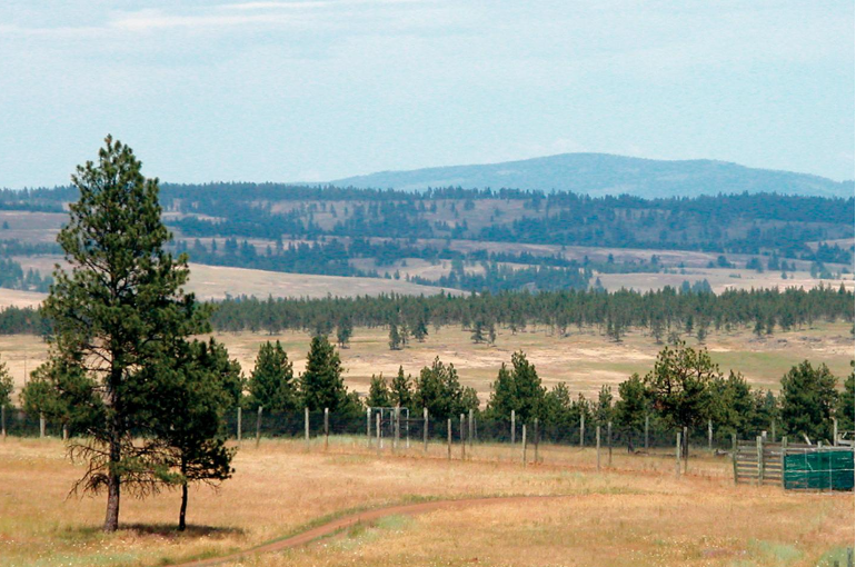
    Upland land cover mosaic in the Meadow Creek Watershed including forest, grassland, and experimental facilities. Reproduced from Costi et al. (2025).

    Combining Knowledge Systems

    Funded in early 2023 through the U.S. Forest Service Collaborative Aquatic Landscape Restoration Program and the Pacific Northwest Research Station’s Northwest Water Initiative, the Meadow Creek Watershed Restoration and Research Collaboration unites CTUIR, the Wallowa-Whitman National Forest, the Columbia River Inter-Tribal Fish Commission, the Bureau of Land Management, Oregon Department of Fish and Wildlife, Oregon State University, University of Idaho, Virginia Tech, and a broad network of tribal, state, federal, and non-governmental partners.

    What distinguishes this effort is the intentional integration of Indigenous Traditional Ecological Knowledge (ITEK) with western research, monitoring, and evaluation (RM&E). For CTUIR, this marks the first time the Umatilla River Vision and the First Foods Upland Vision have been woven into a single, intensively monitored watershed plan. Traditional knowledge of historical conditions, disturbance regimes, and species use is being documented alongside empirical research to characterize ecological baselines and identify meaningful indicators of recovery. A centralized data management system will allow partners to share findings across institutional boundaries and adjust management through an iterative adaptive cycle.

    The Upland Vision and Umatilla River Vision provide the guiding principles for the Meadow Creek Restoration and Research Collaborative. 

    Restoring from Ridge to River

    The restoration strategy is conceptualized around two interconnected spheres: the valley floor and the uplands.

    Valley floor restoration focuses on stream riparian recovery. Treatments aim to reconnect channels to their floodplains, restore native riparian cover, reduce late summer water temperatures, and eliminate fish passage barriers. Because grazing has been a persistent stressor, the team is also evaluating novel management tools, including virtual fencing, to protect recovering riparian vegetation while maintaining agricultural and cultural uses of the landscape.

    Research on the valley floor is tracking hydrologic regimes, fish habitats and populations, aquatic macroinvertebrate and food web dynamics, riparian vegetation structure and function, and the response of native bee pollinators. Researchers are also testing stream and riparian health indicators such as bryophyte communities and Multiple Indicator Monitoring evaluations.

    Upland restoration addresses forest and grassland degradation. In forests, treatments emphasize thinning dense understories and reducing canopy cover to restore stand conditions that favor snow retention, soil moisture, and the growth of berry producing shrubs such as thinleaf huckleberry. Thinning is also expected to improve forage quality and access for elk and deer, while reducing wildfire risk.

    Grassland work focuses on controlling invasive annual grasses and re-establishing native plant communities. Researchers are monitoring the effects of fuels reduction on snowpack dynamics, understory vegetation composition, and the nutritional status of ungulate First Foods. Vertebrate species of conservation interest (including snag-dependent birds, old forest associates, and pollinators) are also being surveyed, alongside small mammals, amphibians, and bats.

    A key objective is to understand how upland forest restoration interacts with valley floor hydrology. By treating the watershed as a connected system rather than isolated project sites, the collaboration hopes to capture synergies that single objective restorations often miss.

    Learning as We Go

    The collaboration has distilled its monitoring agenda into a set of priority questions. How do valley floor treatments affect hydrology and stream temperatures? What are the consequences for salmon, steelhead, lamprey, freshwater mussels, and aquatic macroinvertebrate communities? How effective is virtual fencing in supporting riparian recovery? In the uplands, how do forest treatments alter snow distribution and the timing of melt? Which control methods work best for invasive grasses? And critically, what are the cumulative effects of watershed-scale restoration on native pollinators and culturally significant First Foods species?

    Answering these questions is not merely an academic exercise. The Starkey Experimental Forest and Range, a 25,000-acre research landscape within the watershed, has served as an outdoor laboratory for 40 years, making Meadow Creek an unusually well positioned venue for long term, experimental restoration science. The information generated here is intended to guide not only local management but also restoration policy across the western United States.

    Conceptual diagram of contemporary interactions of management, monitoring, and research in rangelands. Reproduced from McCord and Pilliod (2022).

    Looking Ahead

    Over the next decade, partners will transition from planning to on-the-ground implementation, testing whether a holistic, co-stewarded approach can recover both biological integrity and cultural productivity in a working landscape. If successful, the Meadow Creek collaboration will demonstrate that ecological restoration at the watershed scale is not only biologically necessary but also socially possible with diverse knowledge systems, agencies, and communities moving forward together.

    For more information about the Meadow Creek Watershed Restoration and Research Collaboration, visit https://storymaps.arcgis.com/stories/55eecfedb69241b4bcb98141ba82c66a.

    Collaborative Partners

    These partners are currently engaged in major restoration and research efforts.

    • Confederated Tribes of the Umatilla Indian Reservation 
    • Columbia River Inter-Tribal Fish Commission
    • U.S. Department of Agriculture Forest Service, Wallowa Whitman National Forest, Pacific Northwest Region (Region 6), Pacific Northwest Research Station, and Rocky Mountain Research Station
    • Northern Blues Forest Collaborative (formal collaborative with Wallowa-Whitman National Forest)
    • U.S. Department of the Interior Bureau of Land Management 
    • Oregon Department of Fish and Wildlife Research- Wildlife Division
    • Oregon Department of Fish and Wildlife Research- Fisheries Division  
    • Oregon State University
    • University of Idaho
    • Virginia Polytechnic Institute and State University 
    • Bonneville Power Administration
    • U.S. Bureau of Reclamation
    • U.S. Geological Survey
    • Grande Ronde Model Watershed (non-governmental organization)
    • Eagle Environmental, Inc. (private biometrician services)
    • Oregon Water Resources Department
    • Rocky Mountain Elk Foundation (non-governmental organization)
    • National Council for Air and Stream Improvement
    • Oregon State University Extension
    • U.S. Department of the Interior Natural Resources Conservation Service
    • Oregon Watershed Enhancement Board
    • Union County Soil and Water Conservation District

    Sources

    Most information presented is reproduced from The Meadow Creek Storymap and the Meadow Creek Collaborative Restoration and Research Plan.

  • Natural History and Ecological Restoration in the Madrean Mixed-Grass Prairie of Southeastern Arizona

    Natural History and Ecological Restoration in the Madrean Mixed-Grass Prairie of Southeastern Arizona

    June 25, 2025

    By Matilda Essig

    Matilda Essig is an artist and agriculturalist who has lived in the grasslands of southeast Arizona since 2006. She uses visual art, hands-on restoration and public outreach to express the resilience of wild ecosystems. matilda@mindspring.com

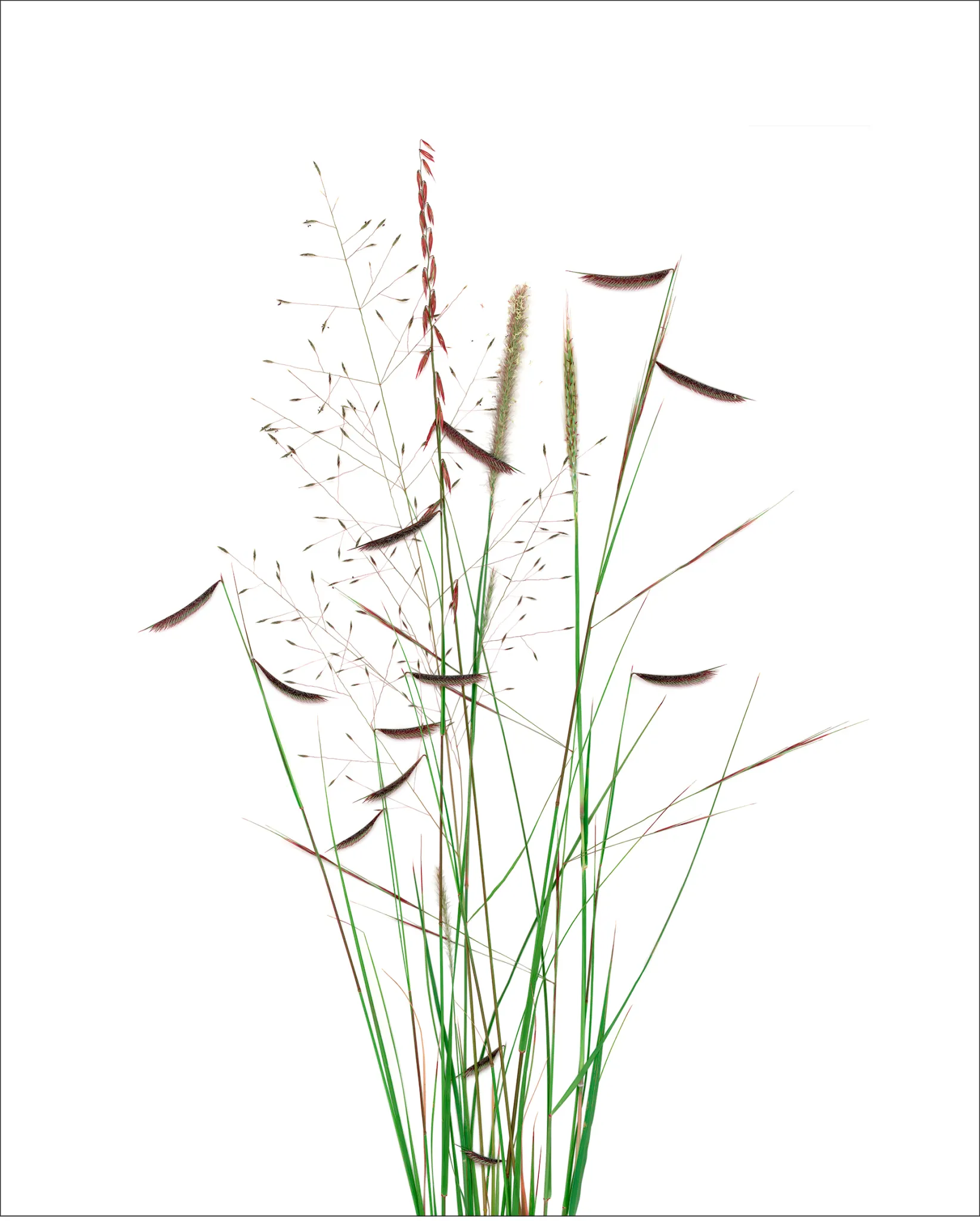
    Blue grama. Digital capture, archival inkjet print by Matilda Essig. Unless otherwise indicated, all images are by the author.

    Nineteen years ago, I began a project to restore the native diversity of the grasslands on a badly damaged 5-acre residential parcel in southeast Arizona, in a region locally known as the Apache Highlands Grasslands, a.k.a. Madrean-Mixed Grass Prairie to botanists, naturalists and biogeographers. My journey was informed and inspired by landscape stewards throughout the American west – ranchers and conservation groups alike. My mission included restoring not just the amazing diversity of grasses in the region, but also using my experiences, expressed through the arts, to help restore the role of art as a visionary vehicle within our culture. Visual beauty, ecological, and spiritual beauty – we need to get in touch with all of them again.

    San Rafael Valley Overview. A monsoon cloud unleashes its fury over Saddle Mountain, headwaters of the Santa Cruz River.

    In 2008, I wrote an article for Ecological Restoration, with my friend, and then-editor Mrill Ingram, wherein I described the conditions and biological makeup of my land. This article, Portraits of Grasses, gave an in-depth description of the biological ingredients I had to begin with, and also the artistic process I learned to use to make direct images from nature, using digital technology.
    At the invitation of my friend James Aronson, I am delighted to share an update here, in NHER, mentioning the methods that worked and failed, and highlighting  native grass species, and sharing how my portraits of these grasses engaged new audiences. What I have borne witness to in my brief tenure as an artist and restoration steward on my small tract of land has given rise to meaningful dialogue across the spectrum of possible audiences, through exhibitions, residencies, studio visits, and the artist’s book that I produced, Native Grasses of the Apache Highlands, which is now available for use in five university library special collections.

    Suite of five grasses. Blue grama (Bouteloua gracilis), Hairy grama (Bouteloua hirsuta), Little bluestem (Schizachrium scoparium), Sideoats grama (Bouteloua curtipendula), and Rothrock’s grama (Bouteloua barbata var. rothrockii). Digital capture, archival inkjet prints.

    The Apache Highlands grasslands – also known as the Madrean Mixed-Grass Prairie, which derives its name from The Madrean floristic region (named after the Sierra Madre Occidental) that occupies the arid and semiarid areas in the southwestern US and northwestern Mexico, at the northern edge of the subtropics. Sandwiched between huge basins and the rocky mountains, it’s a biodiversity hotspot. The summer monsoon delivers the most annual precipitation and is the primary (warm) growing season for the grasses. The San Rafael valley, which spans the US/Mexico border, is home to the southwestern-most intact stand of Shortgrass prairie in North America.

    The Apache Highlands Ecoregion, X marks Matilda’s property. Map by Robert Bailey, The Nature Conservancy.

    According to the late, great desert ecologist Tony Burgess, who passed away in 2022, these were the most characteristic native grasses in my region: Black grama Bouteloua eriopoda, Blue grama, Curly-mesquite grass – Hilaria belangeri, Vine-mesquite grass – Panicum obtusum, Cane beardgrass – Bothriochloa barbinodis, Purple threeawn – Aristida purpurea, Poverty three-awn grass – Aristida divaricata, Plains lovegrass – Eragrostis intermedia, Giant sacaton – Sporobolus wrightii and Arizona cottontop – Digitaria californica. 

    Over the years, I’ve come to recognize many more grasses, some of which I’ll mention below. Sadly, a plethora of invasive grasses and other plants now compete with the natives on my property which is in a subdivision carved out of what was, until quite recently, open grassland.

    Sideoats grama. Digital capture, archival inkjet print.

    The slope is gently north facing, with the buildings situated on the flat area of the ridgetop in the SE corner of my 5-acre property. It has fenced pastures which had been overgrazed by an equine for 20 years, resulting in an abundance of amaranths (Amaranthus spp.) and various kinds of ‘tumbleweeds’ including Salsola spp. (Chenopodiaceae). 

    Among the invasive grasses I had to deal with were Johnson grass (Sorghum halepense), and Lehmann’s love grass (Eragrostis lehmanniana), Yellow bluestem grass (Bothriochloa ischaemum), and the infamous, cosmopolitan weed Skutch grass or Bermuda grass (Cynodon dactylon) that had been planted by previous owners for lawn and equine grazing. My first steps to control the invasives, and promote recovery of the pre-existing flora and vegetation, began with cattle and rotational grazing practices that I learned from neighbors. That was quite successful in knocking back the swarms of amaranths at the start of the monsoonal growing season, thereby allowing the slow-growing grasses to gain a foothold. While I had wanted to work with goats in subsequent years, I chose not to undertake the labor-intensive fencing that would be required to control them and their voracious grazing habits. The cattle had been easy to contain with single strand aluminum wire and a solar charged battery for electricity.

    Five borrowed cattle – a British white park bull, and four criollo heifers – feasting on amaranth and other invasives at the start of the rains and growing season, early July.

    Instead, I invested in a high-quality mower and did a lot of pulling by hand of all the invasive species that I could. In the first few years, my progress was great – eliminating the amaranth completely around the buildings and well into the pastures, and completely extirpating the tumbleweeds, without any chemical assistance. Instead, I set out to learn about the root strengths and soil moisture of each invader species, so as to be able to pull each plant at the most appropriate moment in order to remove the entire root system with minimal soil disturbance. Working to reduce the invasives, I also learned about the natives, as I watched them rebound in the absence of competition.

    Sensing and observing the effects of my role as a player in this ecological equation gave me great inspiration for creating the artworks – to celebrate the grass species that I was learning about, and to share the story of healing the landscape. By healing, I mean restoring the native grasses which I knew, in turn, would be nourishing soil health and ecosystem health. 

    The Grasses

    Out of the more than 100 native Poaceae in the Apache Highlands, the most prevalent and iconic is Blue grama, a recognized keystone species and, now, a keystone also in the communications programs based on my artwork. It was the favorite of my first local mentor, senior rancher John Donaldson, who first taught me about the role of grasses in assisting the recovery of soil and watershed health on the nearby Empire Ranch, now the Las Cienegas National Conservation Area. This species has persisted and rebounded from the impacts of overgrazing on my property, and is notably much beloved throughout the interior western USA and northern Mexico, for its role  as a pillar of many kinds of grassland communities, and because it is palatable and provides high protein content for feed for livestock.

    I had immediate success in portraying the character of this species, and through the strong imagery, it served as a common denominator in rangeland discussion amongst the agricultural communities with whom I met at conferences. In particular, the Quivira Coalition’s 2009 conference on the theme of American conservationist Aldo Leopold was a great opportunity to engage in the dialogue about the role of beauty in land conservation. As I mentioned above, visual beauty, ecological beauty and spiritual beauty are all players, so to speak, in the determination of future land usage decisions based on human values. Sideoats grama, Rothrock’s grama, and Hairy grama were all present and easy to portray, with their vertical postures and  showy inflorescence, but Black grama was a far greater challenge to find and portray, with tiny its slivers of seed head, and prostate growth patterns.

    Black grama. Digital capture, archival inkjet print.

    I’d searched for this species after hearing Brandon Bestlemeyer, ecologist and research leader at the Jornada Experimental Range, describe it as a critical species in the future of grasslands conservation. Many such inspiring collaborative conversations came about in the context of annual science meetings convened by the Malpai Borderlands Group, whose legendary accomplishments in bringing ranchers and conservationists together have resulted in biological protection for vast tracts of open range grasslands in the Chihuahuan desert. My friend Ben Wilder, a biogeographer and communicator with the Next Generation Sonoran Desert Researchers, chose the image of Black grama to draw an audience for a fundraising event for the UA Herbarium and the vast resource of its collections. The image spoke to them about spirit and resilience.

    While my original focus had been to learn everything I could about how and where the individual grasses grow, the point of understanding multiple species was to illuminate the strength that biodiversity creates within the fabric of ecological communities. When the Land Institute, the Kansas-based agricultural research organization working to develop sustainable food crops, invited me to present as Artist for the 30th annual Prairie Festival (2010), they wanted an image for the theme of perennial polyculture. This challenged me to portray a group portrait that was inspired by a series that I collected, just as it occurred, from a pasture of a neighboring rancher, Rukin Jelks, who practiced holistic management methods: a mature rotational cell system designed byAlan Savory thirty years ago.

    Perennial Polyculture. Hairy grama, Plains lovegrass, Sideoats grama, Poverty three-awn, Bristle wolf’s-tail (Lycurus setosus), and the naturalized Afghani bluestem (Bothriochloa bladhii). Digital capture, archival inkjet print.

    The Audiences 

    The audiences at conservation meetings and the Prairie Festival knew the subject and shared my love for it. I believe they even felt their passion for land and prairie conservation was being recognized and honored in a new way. At traditional art venues —museums and galleries —the subject matter was largely novel, reaching audiences in different, more intuitive ways. The resounding response was, ‘I will never look at grasslands the same way again’. The diversity of plant characters also brought out the diversity in my audience:  some viewers related to chaotic images like Tanglehead grass (Heteropogon contortus) whereas others were repelled by it.

    Tanglehead grass. Digital capture, archival inkjet print.

    The audiences of the fine art world were ripe for the authenticity of nature based values, a light of climate change and then the pandemic. At Tucson Museum of Art, (2013) I worked with the curator to produce a large group exhibition called “Desert Grasslands”, which offered side events such as art-science panel talks about rangeland conservation, Buffelgrass (Pennisetum ciliare, formerly calledCenchrus ciliaris),  the noxious and highly flammable invasive that now threatens the Sonoran desert. 
    At the Amerind Museum, I had a solo show for Native Grasses of the Apache Highlands,(2016) and was able to engage with Hopi and Navajo tribal members in a shared sense of spiritual and creative source in the natural world. At the Willa Cather Foundation my solo show focused on comparing the prairie grass characters to Cather’s meticulous human portraits of pioneer immigrants – studies in adaptation and resilience. At the Tucson Airports’ Center Gallery, in 2019, I was able to offer the work to the broadest audience yet, and also use the setting to meet with visiting classical composer Emerson Eads to discuss collaborative musical intentions, and also Indigenous author and botanist Robin Wall Kimmerer.

    Over Time

    While an extreme weather event in 2021 – 3 inches (75 mm) of rain in one hour – reversed years’ of hard work in a single episode, leading to the germination of an ‘avalanche’ of amaranth seed that had likely lain dormant for more than a decade, the subsequent two years of sustained drought allowed a favorite native grass of mine to appear – Sand dropseed (Sporobolus cryptandrus)- in uncanny abundance. Additionally, as I grew to learn the songs of grassland birds, my restoration priorities expanded to include the habitats of the avian species that also thrived from my work, Meadowlark and Scaled quail in particular.  The meadowlark’s song is both ancient and evolving in this landscape, as we have eastern, western, and also a new Chihuahuan subspecies recently identified by its song. The invasive plants have also inspired their own folio, currently underway.

    In conclusion,  my intentions moving forward are to work with the folios in university settings, to challenge our culture-driven perceptual paradigms of the natural world, engaging the next generation with the inspiration of stewardship thinking, both from conceptual understanding through the stories of these many land managers, and also to inspire them to see their own potential hand in the process, to experience the role of healer, and to know that no matter how small or large a parcel or landholding they may be working on, five acres or fifty thousand, every gesture makes a difference. To that end, I look forward to further opportunities to collaborate with EHN and its partners, to help inspire acts of ecological restoration, and to offer the arts as a catalyst for all.

    Matilda on Flecha, looking north across the San Rafael Valley, headwaters to the Santa Cruz river. Saddle Mountain and the Santa Rita Mountains in the background. Photo by Zay Hartigan.

    I would like to express my gratitude to James Aronson and Lauren Shew for editorial and technical assistance in creating this post.