By James Faupel & Caity Sims
James Faupel is the urban ecology restoration supervisor at the Litzsinger Road Ecology Center (LREC) and Caity Sims is the Project Clear restoration coordinator. The LREC is a private, urban outdoor education site in the heart of Metropolitan St. Louis, Missouri that is managed by the Missouri Botanical Garden for educational programming with K-12 teachers and students, and supported by many local university-based researchers.
Part 1: by James Faupel
Anticipating Loss
In September of 2018, when I took on the lead restoration ecologist role at the Litzsinger Road Ecology Center (LREC), I was aware of the impending utility pipeline project (Project Clear) that would impact around a quarter of this education center’s restored habitats and the adjoining urban Deer Creek. The 15.8-hectare (39-acre) ecology center combines a mix of reconstructed bottomland prairie and restored riparian woodlands, with a stretch of urban creek in surprisingly good ecological condition. I knew this was a unique opportunity to set up a long-term study to examine the processes of reconstructing tallgrass prairie following major anthropogenic soil and landscape disturbance, a topic with little previous research, especially in urban areas.
The 6.3 km (3.9 mile) long Deer Creek branch of Project Clear was slated to dissect a 0.8 km (0.5 mile) long swath of LREC’s restored habitats – a pretty significant amount of collateral damage. To be clear, the purpose behind Project Clear’s sanitary pipeline path is well intentioned. The Metropolitan St. Louis Sewer District’s (MSD) Project Clear is a six billion dollar, 28-year long initiative to improve water quality and alleviate many wastewater concerns related to the frequent sewage overflows of the legacy sewer system of the St. Louis region. Cleaner water in Deer Creek would mean healthier breeding and feeding conditions for a wide variety of wildlife that live in or rely on the water of the creek, as well as healthier adjoining ecosystems, and much healthier domestic water supplies for human residents of St Louis County. The collateral damage of the MSD Deer Creek branch was 6.3 km (3.9 mile) of riparian habitat was damaged, degraded or destroyed.

As discussed in a previous NHER blog post on the topic, urban prairie reconstructions are important tools in the toolbox of prairie education to the general public and in saving North America’s prairie remnants. Remnant prairies are invaluable fragments of a once vast grassland ecosystem of the Midwest and are now one of the most endangered ecosystems in the world. Getting the chance to expand the area covered by reconstructed prairie at an educational site like LREC was an opportunity that I did not want to miss. The downside was that the LREC restoration team would have only one year to gather baseline data before the sanitary pipeline construction began, and I also had to fit in learning all of the other ins and outs of my new role.
Throughout 2019, with the assistance of LREC volunteers, interns, and partner researchers from local universities and organizations, we were able to gather a wide array of baseline data that could be used as a comparison in the years ahead, once the future restored prairies are older. In 2019, the previously restored habitats at LREC were 30 years old, among some of the oldest restored habitats in the St. Louis region. Restoration projects of this age are incredibly valuable for ecological research projects looking to better understand anthropogenic impacts on the environment around urban centers and to learn best practices for effective, long-lasting restoration efforts. They are priceless.
During the growing season of 2019, we were able to survey all the vascular and nonvascular plant species growing in the proposed pipeline path and adjoining areas, as well as survey for birds, bees, spiders, ants, and algae thanks to the varied expertise of all involved. Baseline samples were collected of the upper soil horizons along the entire pipeline path, in addition to a complete inventory of all of the trees and shrubs that would be removed during construction so we could assess their value. The most significant baseline dataset is that of Elizabeth Hasenmueller and her Lab at Saint Louis University, who had been studying the water quality of Deer Creek at LREC for five years prior to the sanitary pipeline installation and are excited to continue this research, hoping to capture more data and test hypotheses concerning the hydrology and geochemistry of this urban stream as water quality improves with the removal of the sewage overflows from the creek.

Deconstruction of Habitat
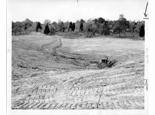
On September 30th, 2019, construction vehicles arrived on the grounds of LREC, and began the month-long habitat removal on site. In what felt like the blink of an eye, a large section of one of the oldest prairie reconstructions in the St. Louis region, along with 746 individual native trees and shrubs, were gone and no longer providing any ecological or educational services. It was quick, like a bandage being ripped from the skin.

Left: October 2018. Right: August 2020 (Google Earth 2019, 2021).
The pipeline installation process, from start to finish on LREC property, lasted nearly three years. Following the removal of all the preexisting habitat, work began on trenching the ground open, dynamiting the bedrock, installing the sewer pipe, reworking the now homogenized limestone bedrock/C horizon soil mix back into the trenches, restabilizing the streambanks from their stream crossings, and finally grading the soil out to pre-construction elevations. We knew from the beginning of their trenching process that we would ultimately be trying to grow native prairie plants in a “novel ecosystem” with soil conditions that would never co-occur with them in nature.
Throughout the construction process, there was plenty of time for planning how we would restore the land once it came back into our hands, as well as how we would monitor it long term. There is little research that has been done on the topic of prairie reconstruction following major anthropogenic soil disturbance. Initially we thought it would be beneficial to test many different methods of soil remediation ahead of the seeding of native prairie plants in different study plots. However, during the three year construction period, there were several major flooding events from the adjacent Deer Creek that changed our minds. The regularity and increasing frequency of these flash flood events of this urban creek made us take pause and the aforementioned research idea was scrapped. These events aren’t likely to lessen anytime soon, as the area covered by impervious surfaces in the surrounding watershed continues to grow. Future flooding events would introduce too many confounding variables to any kind of research that compared the outcomes of various soil remediation methods to make it a worthwhile investment of our time and resources.

In late summer of 2022, the property was handed back to the staff at LREC to begin the habitat reconstruction work. By this point in time, I had been promoted to a supervisor position at LREC and had many more responsibilities that took me away from being able to dedicate significant time to the Project Clear pipeline restoration project. Our two summer interns that year assisted with the second round of soil sampling for comparison to the baseline soil data and an inventory of all of the plants that naturally colonized the disturbed areas along the entirety of the pipeline path that year. For information from that botanical inventory, you can read our article that was published in the 2022 volume of Missouriensis. Our immediate reconstruction plans were to bring in a contractor that could quickly get annual cover crops down and hopefully germinate and root into the compacted soil before any fall or winter flooding events occurred. We also planned for a major seed collecting effort in 2023, so that we could sow a wide variety of early successional native species onto the pipeline path in late fall of 2023, or before the first snow of winter.
With my role having been redirected away from the pipeline path reconstruction, I lobbied for a new staff member that could replace me and focus all their efforts on the reconstruction, research, and monitoring of this important project. Caity Sims was hired for the role of coordinator of the project in January of 2023 and hit the ground running. It has been an incredible year mentoring her throughout this process and I look forward to exploring the reconstructed prairie habitat she will be establishing and chaperoning with our amazing team of volunteers, staff, and interns over the next few years.
Part 2: by Caity Sims
Before Reconstruction Began
I was fortunate enough to witness the LREC before Project Clear as a summer intern in 2019. That summer, I assisted with collecting pre-deconstruction baseline data on trees and the algae found in Deer Creek. After my internship, I left St. Louis for Jonesboro, Arkansas to earn a master’s degree focused on botany in the Mississippi Alluvial Plain. Ready to apply my botanical and research skills in the working world, I returned to the LREC in January 2023 as the Project Clear restoration coordinator. I was shocked to finally see first-hand the impact the pipeline construction project had had on the riparian, woodland, and prairie ecosystems of LREC. What seemed in my memory like a maze of bottomland woodland was reduced to a scanty wooded edge surrounded by a sparsely vegetated brown strip of fallow land.
Before I joined the LREC team, a cover crop of common wheat (Triticum aestivum) had been seeded onto a majority of the pipeline path in winter 2022. Around the same time, a six-species cover crop mix, consisting of crop grasses, common pea, and field mustard (Brassica rapa) was seeded onto the southern section of the path. Cover crops mend the soil by adding nutrients, perforating the soil for better water infiltration, outcompeting weedy species, and preventing erosion of bare soil.
Unfortunately, the first round of cover crop mixes did not do well, and by mid-April the common wheat was barely a foot tall and had already gone to seed. The mixed species cover crop did not grow on most of the seeded area of the southern section due to flooding washing away a majority of the seeds. The path desperately needed a second cover crop at that point, so we hired contractors to seed the warm season crop, Sudan grass (Sorghum bicolor), onto the majority of the path again and a nine species cover crop mix onto the southern section. The Sudan grass did much better, growing to heights of over six feet in some areas. Although the mixed species cover crop seemed to do better, the extreme summer heat drying out the compacted soils resulted in depauperate mature plants. There were many areas directly over the pipeline that seemed unlikely to hold any vegetation at all.

Despite environmental conditions being heavily anthropogenically impacted, a good number of native early successional and bottomland species grew alongside the cover crops on the path. I was surrounded by many familiar disturbance-prone and riparian species, as my master’s thesis had focused on plants growing on Mississippi River islands. I recorded 310 species growing on the entire path after completing vegetation surveys in 2023. As I expected, some of the most common species were yellow foxtail grass (Setaria pumila), southern crabgrass (Digitaria ciliaris), barnyard grass (Echinochloa crusgalli and E. muricata), hairy seed crowngrass (Paspalum pubiflorum), late boneset (Eupatorium serotinum), and tall goldenrod (Solidago altissima), all of which thrive in disturbed environments.
As I work toward reconstructing the land to improve structure and function of the ecosystem for many native organisms, I need to quantify the results of this effort. To measure the changes in plant communities along the pipeline path over time, I established dozens of permanent vegetation monitoring plots along the path that will be monitored every summer. For each plot, I collect the presence and percent cover of each species in the plot. I am hopeful that by 2027, native prairie plants will constitute 75% of the flora and vegetation in every plot.

Also found post-pipeline construction were two species new to Missouri: Centaurium pulchellum, and Myosotis arvensis, and three new to St. Louis County records: Sesamum indicum, Cyclospermum leptophyllum, and Krigia cespitosa. All record species are not native to Missouri except K. cespitosa, which has been recorded from neighboring counties. It’s not uncommon to find new state or county records in disturbed areas. For more detailed information about those species, their identification, and potential explanations for their introduction to the LREC, check out my article in the 2023 volume of Missouriensis.
We have classified several different habitat types on the pipeline path including wet depressions and ephemeral ponds, rocky upland (i.e., “glade”), creek bank, woodland edge, and fallow ground. Due to a permanent pipeline access easement built and maintained by the Metropolitan St. Louis Sewer District (MSD), we cannot reconstruct the bottomland woodland that was destroyed. However, we can reconstruct a bottomland prairie on a majority of the path where the fallow ground with rocky and compacted soil are the most prominent. In the wider southern section, we will reconstruct a savanna that will include tree plantings outside of the MSD’s easement.
Going Forward
Staff and volunteers collected seed throughout the 2023 growing season. We focused on collecting species with Coefficient of Conservatism (C-Value) ranks of six or below, which is consistent with the range of C-values observed in the 2022 vegetation survey of the path. The coefficient of conservatism (or C-scores) is an index ranging from 0-10, representing a species’ fidelity to intact remnant or long-restored habitats, as determined by local botanical experts. Species with higher C-scores are less tolerant of environmental degradation and increasingly restricted to high quality sites. Species with C-Values from 0-6 are likely to be found in disturbed and early successional environments, while species with C-Values from 7-10 are more likely to be found in near-pristine and remnant environments (Ladd and Thomas 2015). High C-Value species are harder to establish in restored and reconstructed habitats.
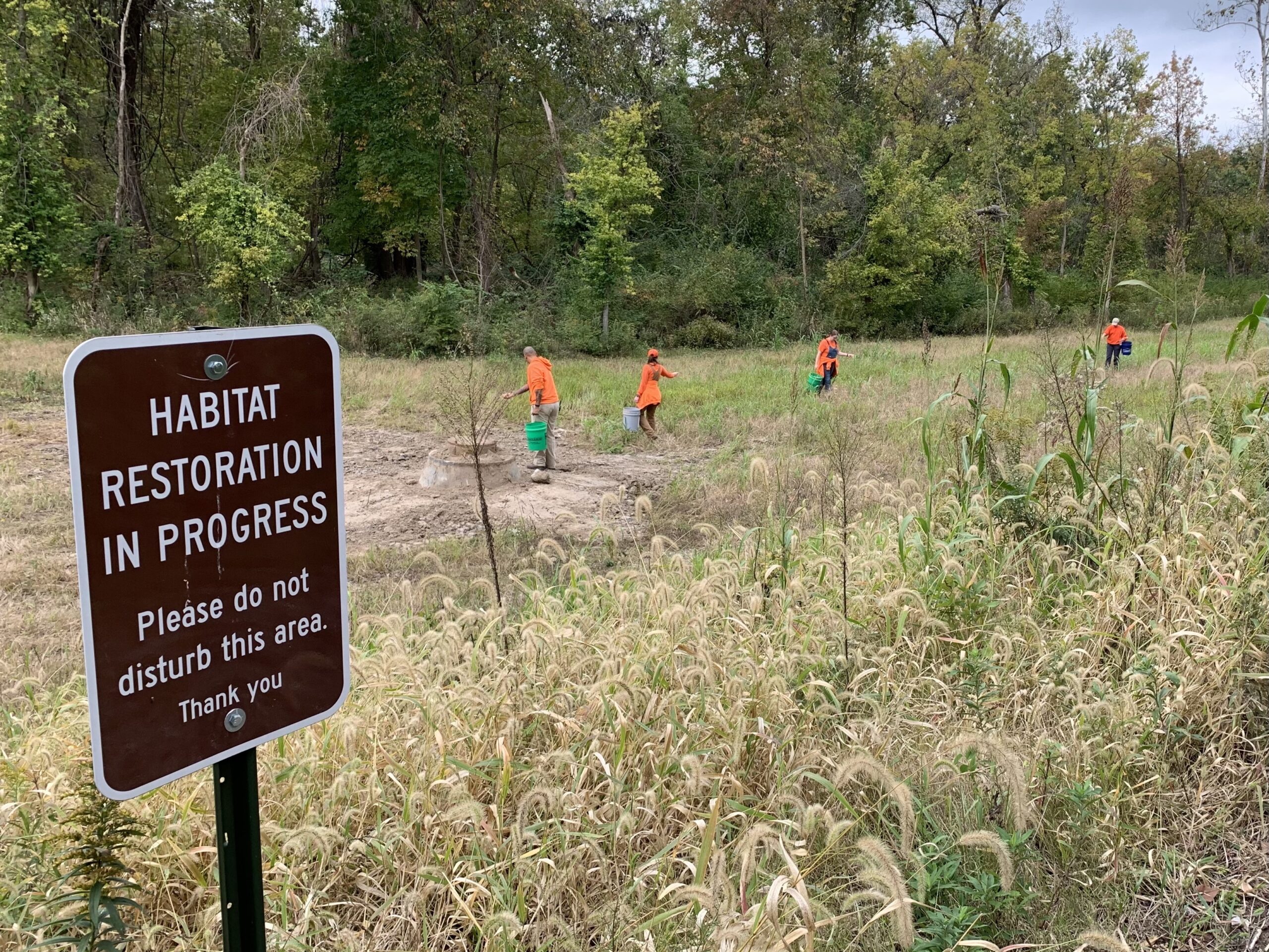
Summer and fall interns focused mainly on seed collection, cleaning, and organization to prepare for the 2023/2024 winter seeding. It was a monumental effort with amazing results. We collected seeds from 96 species in 2023 for a total weight of 49 kg (108 lbs) of mostly Pure Live Seed (PLS), with some chaff. In addition to collecting seeds, contractors have drilled 39 prairie species onto the pipeline path seeding a total of 16 kg (36 lbs) of PLS. We also added seeds collected in previous years that were housed in seed storage at the LREC. Including the 2023 collected seed, the PLS from contractors, and the previously collected seed, a total of 189 species with a total weight of 74 kg (164 lbs) was seeded on the pipeline path. To view the results of our seed collecting effort in 2023, please see our interns’ compiled end of season unpublished report.

I am hopeful that the seedings will be successful and signs of a prairie will begin to emerge this year. However, flooding and poor soil conditions are major issues on the pipeline path. I have already dealt with the aftermath of floods washing away cover crops and soil, and remaining soils lacking suitable nutrients and structure for plant growth. These are out of my control, so all I can do is accept them, keep trying, have patience, and not let frustration get the best of me.
In three years, I anticipate less introduced and early successional species as they fail to compete with the maturing perennial natives. I envision more pollinator observations on the former pipeline path as the prairie species begin to bloom. After the third growing year, we may be able to burn the young prairie and savanna. In 30 years, I hope to return to see restored prairie, savanna, woodland, and creek habitats functioning as home to a diversity of plants, insects, birds, reptiles, amphibians, mammals, and microbiota like the undisturbed LREC habitats do today.