Tag: Restoration

  • From green and blue forests to social-ecological restoration: restoration futures in southern Chile

    From green and blue forests to social-ecological restoration: restoration futures in southern Chile

    By Matías Barceló

    Matías Barceló is an early career researcher at the Centre for Research and Innovation on Climate Change (CiiCC) at Santo Tomás University, Chile, SECOS Institute and at the Laboratory for Ecosystem Conservation and Human Well-being (LabCBH). His research focuses on local communities and the land-sea interface. In particular, he has worked on assessing the role of local knowledge in adaptive capacity in a rapidly changing world, as well as investigating the various perceived values of nature associated with the various practices of local communities. He is currently assessing how these values can reinforce various initiatives to restore and reconnect degraded and fragmented ecosystems at the land-sea interface.

    Chile is often described through its contrasts: deserts, mountains, temperate rainforests, mediterranean-type climate ecosystems, fjords, kelp forests, and one of the longest coastlines in the world with 4,200 km from north to south, roughly the distance from Lisbon, Portugal, to Moscow, Russia. When accounting for its islands, fjords, channels, and intricate geography, its total coastal perimeter exceeds 80,000 km. These ecosystems also include areas of exceptional conservation value, including the globally recognized Chilean Winter Rainfall–Valdivian Forests Biodiversity Hotspot in central and southern Chile. 

    A map of South America showing Chile (in red) surrounded – and isolated – by the very high Andes mountain range and the Pacific Ocean. Image-generated by Matías Barceló.

    Restoration in Chile is growing, but in what way, and in what direction?

    Our recent review of 95 restoration initiatives, that comes from a dataset compiled by the Chilean Ministry of the Environment, showed that most projects nation-wide are concentrated in terrestrial ecosystems, particularly in central and south-central Chile, where wildfires and forest plantations are among the main drivers of degradation and transformation (see Figure below). Our work showed that 94.7% of the initiatives were terrestrial while the other 5.3% represent wetlands and there are no initiatives in the database focused directly on marine ecosystem restoration, despite Chile’s extensive coastline. 

    This review also revealed a key social gap: only 35.7% of the initiatives explicitly involved local communities from the outset, and when communities were included, their role was often limited to operational activities such as planting, cleaning sites, or basic monitoring. In other words, people participated in restoration activities, but not necessarily in defining restoration goals, identifying priority areas, making decisions, or shaping governance processes.

    The map on the left shows the restoration initiatives recorded by Chile’s Ministry of the Environment between 2010 and 2021, marked with red dots. The panels on the right summarize key features of these initiatives, including: (A) main causes of site degradation; (B) ecosystem type; (C) land use or land cover targeted for restoration; (D) whether actions involved water bodies; (E) whether local communities were involved; (F) whether seeds were collected from nearby areas; (G) whether seedlings were produced by the initiatives; (H) whether planting was carried out; (I) whether monitoring was in place; and (J) whether a reference ecosystem was selected or assembled.

    This is relevant because as mentioned above restoration work should reach beyond ecological goals. If restoration projects focus exclusively on biophysical recovery, they may overlook local livelihoods, cultural values, traditional practices, historical relationships with species, and also the meanings that communities attach to degraded or transformed landscapes. A restoration project can be technically well designed and still fail socially if it does not engage with the people who live in, depend on, and care for those ecosystems. The challenge is to move toward social-ecological restoration, an approach that integrates ecological recovery with local knowledge, values of nature, community participation, and long-term human well-being.

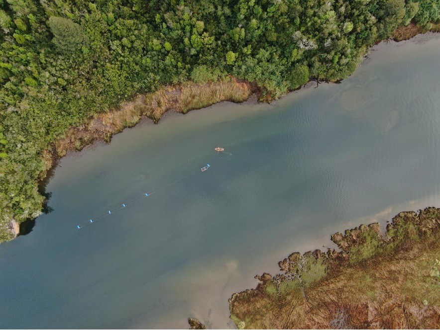
    The mouth of the Chaihuín River where it flows into the Pacific Ocean is a highly representative location for studying land-sea interactions via the river. Chaihuín, Valdivia, Chile. Photo credit: Matías Barceló.

    Why land and sea must be restored together

    Although terrestrial and marine ecosystems are often managed separately, many communities experience them as interconnected territories. Changes in one part of the system can affect the others. Forest degradation can influence water quality, sediment flows, coastal habitats, and livelihoods. Marine degradation can affect food security, local economies, cultural practices, and people’s sense of belonging.

    Drying red seaweed species for marketing purposes on the southern coast of Chile. Photo credit: Matías Barceló.
    Artisanal divers checking water quality monitoring equipment. Photo credit: Matías Barceló

    For this reason, we have undertaken a project that focuses on representative coastal sites of southern Chile: Lenca, Puelo, and Cochamó (see Figure below). These places were selected because they represent different but connected expressions of the land-sea interface in the south-central Regions. Lenca combines temperate rainforest, proximity to Alerce Andino National Park, artisanal fishing, seaweed harvesting, and coastal livelihoods. Puelo connects mountain, riverine, freshwater, and marine systems. Cochamó brings together valleys, temperate forests, rivers, coastal areas, artisanal fishing, shellfish harvesting, and community-based tourism. Together, these sites offer a unique opportunity to ask and test how restoration can be conceived not only for “nature”, but also for people.

    (a) Dots indicate the study site locations: Lenca (red), Cochamó (yellow), and Puelo (light blue) in Reloncaví (Llanquihue Province, Los Lagos Region), southern Chile. (b) Pink dots show the locations of the study sites in a subcontinental geographic context. Maps created by Matías Barceló.

    From ecological restoration to social-ecological restoration

    Our project starts with the idea that restoration priorities should be defined by integrating ecological evidence with local perceptions. It combines remote sensing analysis of native and kelp forest change with interviews with local actors about perceived environmental changes, key species, threats, and meaningful places. This information will be co-validated with communities mentioned above, recognizing that scientific data alone is not enough to guide restoration, and that local knowledge is essential to understand degradation and identify restoration needs.

    Why values matter for restoration

    One of the main contributions of this project is its focus on plural values. People value ecosystems in different ways: some values are instrumental like forests and marine ecosystems that provide food, income, materials, protection, or tourism opportunities; others are intrinsic: species and ecosystems may be considered valuable in themselves, regardless of their usefulness to people. But many values are relational: they emerge from identity, care, memory, responsibility, belonging, and connection to place. These relational values are especially important for restoration.

    Our project will explore these values through photo-voice. Participants will be invited to take photographs of places and species that are meaningful to them. Each photograph will be accompanied by a short narrative explaining why the place or species may be relevant for restoration. This method will allow to communicate environmental change not only through words, but also through images, memories, emotions, and territorial experience.

    Co-creating restoration futures

    Our project moves from diagnosis to action. One approach is relevant here. Pockets of the past, which invite communities to identify values, practices, or ways of life from the past that they want to carry into the future. These may include forms of care, uses of species, relationships with rivers or forests, collective practices that remain meaningful for sustainable futures.

    This approach suggests that restoration initiatives can be more legitimate and sustainable when they are grounded in local values, ecological evidence, and community priorities. In this sense, community-led pilot initiatives and methodological guides can serve as useful tools to translate plural and relational values into restoration practice. They offer a pathway for moving from diagnosis to action, while also generating lessons that may be adapted to other land-sea territories facing similar social-ecological challenges.

    A window of opportunity: restoring relationships in southern Chile

    Chile currently finds itself in a unique institutional moment. The National Landscape Restoration Plan 2021–2030 and the newly established Biodiversity and Protected Areas Service that opens a major opportunity to embed social-ecological restoration into national policy and planning. This opportunity will only be meaningful if restoration moves beyond narrow ecological targets. 

    Land-sea interface in southern Chile, showing an area used for mussel farming, which is subject to terrestrial environmental changes resulting from potential land-sea interactions. Photo credit: Felipe Torres.

    Restoration is often imagined as the recovery of what has been lost such as forest cover, indigenous species, habitats, ecosystem functions. But degradation can also weaken what is relational: knowledge, memories, practices, livelihoods, and the sense of belonging that connects people to place. Restoring green and blue forests in southern Chile is not only about recovering trees or kelp. It is also about strengthening relationships that make restoration meaningful: relationships between people and nature. By placing plural values and community participation at the center, this project seeks to contribute to a broader transformation in restoration practice to build more sustainable, just, and place-based futures. 

    This research is funded by The National Agency for Research and Development of Chile (ANID) and it is just getting started; if you’re interested, please don’t hesitate to contact the first author at barcelo.matias@gmail.com.

    I gratefully acknowledge the collaboration of my friends and collaborators Claudia Rojas & Alejandro Venegas‐González.These gaps and lines of research stem from our recent paper in Restoration Ecology.

  • Reintroducing Kenya’s Threatened Trees and Shrubs in the Highlands Through Science and Community Action

    Reintroducing Kenya’s Threatened Trees and Shrubs in the Highlands Through Science and Community Action

    By Tobin Mutiso and Andrew Gichira 

    Tobin Mutiso is a research associate at the Centre for Ecosystem Restoration Kenya (CER-K). He works on plant ecology and taxonomy. He holds a BSc in plant ecology and environmental science from Jomo Kenyatta University of Science and Technology. Email: tmutiso@cerkenya.org

    Andrew Gichira, PhD, is a botanist and restoration ecologist specialising in conservation genetics and ecosystem restoration. He currently serves as the head of research at the CER-K. Email: agichira@cerkenya.org

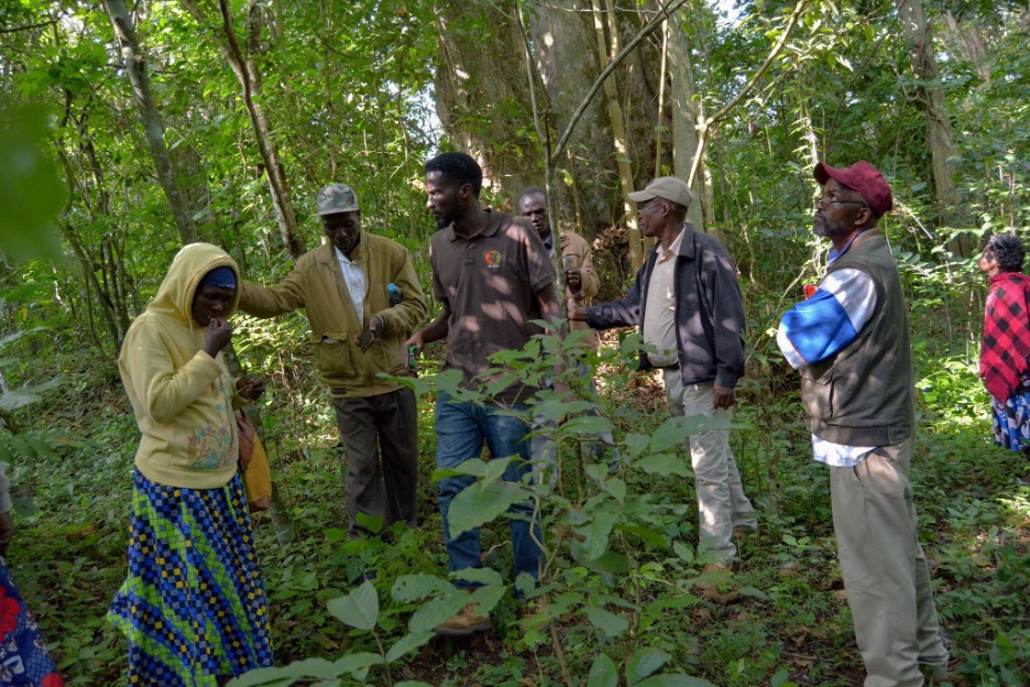
    Members of Community Forest Association (CFA) and trainers standing beside a mature Euphorbia cussonioides at Blue Post, Thikaafter a training on phenology monitoring, seed collection, and species-specific propagation techniques. Subsequently, other seedlings and mature individuals of this species were identified in Ndula Village, approximately 22 km from this site. Photo by Tobin Mutiso.

    The loss of native plant diversity is reshaping Kenya’s ecosystems in ways that are often subtle but deeply consequential. As woody plant species disappear, so do the ecological functions they support, including soil stabilisation along rivers, food and habitat for wildlife, local climate regulation, and cultural and livelihood values tied to native landscapes. According to the IUCN Red List, national reports, and NGO summaries assessing East African trees, roughly 13% of Kenya’s native tree species are threatened with extinction. Most persist in small, isolated stands where natural regeneration is compromised. 

    Natural regeneration becomes increasingly difficult for woody species with very small isolated populations in fragmented landscapes. This is because plants depend heavily on trophic interactions such as complex plant-pollinator relationships.  When these factors are compromised, seed production becomes irregular, which is further compounded with limited capacity of seedlings to establish in degraded and altered habitats. Even in places with improved protection, these species often fail to recover without deliberate conservation intervention. This reality presents a challenge for restoration efforts that rely heavily on a narrow set of fast-growing or readily available species, leaving threatened trees further marginalised and the ecosystems in which they are a key part vulnerable to further degradation and fragmentation. 

    Tree and shrub planting initiatives are expanding rapidly, but their contribution to biodiversity recovery depends on whether the species planted match local ecological conditions. Evidence-driven species selection, combined with local capacity to manage planted trees, remains unevenly distributed across projects, with technical guidance often outpacing on-the-ground monitoring. Threatened plant species, in particular, require targeted support, including improved data on their distribution, a deeper understanding of their ecology, tailored propagation and reintroduction protocols, and long-term care, which can be integrated into local land-use systems.

    Our project aims to investigate whether a species-focused reintroduction model can be effective in real-world conditions. Working with community forest associations, we have selected 22 threatened tree species, developing propagation methods for each and planting them in multiple sites managed by local communities. The central question is whether ecological restoration, species reintroduction and livelihood benefits could be pursued together without compromising the other. By integrating herbarium records, expert knowledge, targeted field science, and community engagement, we are building a reintroduction and restoration model that is both ecologically fit for purpose and socially sustainable, as well as adaptable to other landscapes facing similar biodiversity loss.

    The project is within the Kenyan Highlands, a section of the complex montane ecosystem in East Africa characterised by high habitat heterogeneity and notable levels of biodiversity and endemism (Gehrke & Linder, 2014; Dagallier et al., 2020). Kenya is subdivided into seven plant divisions (K1-K7), which are largely based on the early administrative boundaries (Zhou et al., 2017). Our surveys targeted multiple elevation zones, with a primary focus on the K4 region (1,500–3,000 m) within the central highlands and additional coverage of K7 (Taita Hills, 600–1,640 m) and K6 (Loita Forest, 2,000–2,300 m). Several focal species occur outside the central highlands but occupy comparable altitudinal ranges elsewhere in the country. This broad elevational gradient contributes to high floristic diversity, making the K4 zone a hotspot for Rare, Endangered, and Threatened (RET) species, particularly those of high conservation and use value, including timber and medicinal species such as Ixora scheffleri subsp. keniensis Bridson,  Prunus africana (Hook. f.) Kalkman  and Warburgia ugandensis Sprague.

    The seven phytogeographical divisions recognised in the Flora of Tropical East Africa. K4 and K7 are the most species-rich regions: K4 represents the central Kenyan highlands (~ 1,200–3,000 m above sea level). K7 mainly comprises the coastal lowlands of Kenya (0–150 m.a.s.l.) with some inland highland areas e.g., the Taita Hills (~1,000–2,200 m.a.s.l.). K2 zone also covers the Ilemi area at the northern border. This study focuses on threatened plant species occurring in high-elevation habitats (1,500 m – 3,000 m.a.s.l).

    Starting in the Archives: the herbarium as a roadmap

    This work began not in the field, but at the East Africa Herbarium at the National Museums of Kenya. Herbarium specimens, some collected more than a century ago, provided the most reliable baseline for understanding where threatened tree species historically occurred. We also consulted international databases, most notably the Global Biodiversity Information Facility (GBIF). These collections helped trace former distributions, habitat preferences, and altitudinal ranges for species now rarely encountered in the wild.

    Table 1: A list of 22 woody species that were targeted for the study based on observations recorded at the East Africa Herbarium and the Global Biodiversity Information Facility. Accessed in June, 2022.

    This archival work was complemented by key informant interviews with experienced taxonomists. Their insights helped resolve identification challenges, clarify taxonomic updates, and flag species frequently overlooked in restoration programmes. Surveys of commercial nurseries in the coastal regions further highlighted how threatened native trees and shrubs are systematically neglected in favour of exotic or common species. Literature reviews added further context, helping reconstruct historical range patterns and identify priority floristic regions for field verification. Together, these sources allowed us to move beyond generalized restoration species lists and ask more focused questions, specifically: where do these threatened species still exist, where have they been lost, where does restoration make sense, and, can we create a socio-economic model that sustainably uplifts the livelihoods of local communities while also supporting efforts for ecological and biocultural restoration? 

    Field expeditions and new records

    Guided by this evidence, we carried out targeted field expeditions across multiple landscapes in the Kenyan highlands, spanning 11 counties, including Taita Hills, Kijenge Hills, Thika, Irangi Forest, Ngaya, Thushi River, Nyambene Hills, Imenti Forest and Karura Forest, as well as selected dryland and forest-edge systems, in particular the Loita Hills. These surveys were designed not just to confirm presence or absence but to generate practical ecological insights for restoration practitioners.

    Map of survey areas in the Kenyan Highlands. The sites are distributed in phytogeographical zones K4 and K7, with a single record in K6.

    In several locations, fieldwork led to the identification of new records or previously undocumented populations. The most significant findings surrounded Euphorbia cussonioides (CR) and Brucea macrocarpa (EN), both species whose known populations have declined significantly in recent decades. Newly recorded individuals and regenerants provided urgently needed information on the species’ current area of occupancy and viable seed sources, as well as evidence that recovery is still possible if sites are protected and managed. Observations of flowering and fruiting patterns revealed clear opportunities for seed collection and assisted regeneration. Other threatened species encountered during surveys included Ixora scheffleri subsp. keniensis (CR), Embelia keniensis R.E. Fr. (CR) , Encephalartos kisambo Faden & Beentje (EN), and Vepris hanangensis (Kokwaro) Mziray (NT). 

    Table 2. Newly documented populations and occurrence records of selected threatened woody plant species.

    Newly documented natural regeneration (wildlings) of Euphorbia cussonioides were recorded during field surveys at Nkopon village in the Loita Hills. Photo by B. Maina.

    At each site, we recorded location, habitat condition, land-use context, population structure, regeneration status, threats, and phenological stage. This level of ecological detail transformed field observations into decision-ready data, helping bridge the gap between research and restoration action.

    Communities as conservation partners

    From the outset, the project treated local communities as central partners and not just beneficiaries. In areas where threatened species occurred on private or community-managed land, we worked closely with landowners, community forest associations (CFA), and local scouts to monitor the phenophases and liaise with local nurseries in propagating the seeds. In addition, the Kenya Forest Service (KFS) provided planting locations and collaborated with the CFAs to oversee and care for the seedlings.

    Training focused on practical, transferable skills, in particular: educating the community on the reasons we conserve plants, identifying threatened tree species, monitoring phenology to track flowering and fruiting cycles, collecting seed ethically with genetic diversity in mind, and applying appropriate propagation techniques. We engaged and trained 138 community seed collectors active as community phenology monitors and seed collectors.

    Community members in Embu, Kenya, are undertaking phenology monitoring and seed collection during a training session at Ngaya Forest. Photo by T. Mutiso.

    At Ngaya forest, Thika’s Blue Post, Kasigau (Taita) and Upper and Lower Imenti forests, community members were trained to identify threatened woody species in situ using diagnostic morphological traits, to map and tag individual plants, and apply basic protection measures to reduce disturbance. They also monitored flowering and fruit development to inform seed collection and to rescue naturally regenerated wildlings at risk from competition with invasive species, most notably Lantana camara. This hands-on engagement directly supported the propagation of Brucea macrocarpa,Pandanus kajuiGymnosporia keniensisCylicomorpha parvifloraPremna maximaVepris glandulosa, and Euphorbia cussonioides.

    Pandanus kajui seedlings propagated in Kithunguthia (Embu) community nursery. Photo by T. Mutiso.

    These efforts produced tangible outcomes, with over 28,000 seedlings of threatened species raised in community nurseries in Antubetwe (Ngaya Forest), Kasigau (Taita), Kithunguthia (Embu), Male (Laikipia), Kenya Forest Service (Meru), and Kamaruki (Nyambene), thereby creating viable restoration planting stock. Livelihood benefits were created through project-funded payments for seed collection, nursery establishment and management, and continued after-care management of planted seedlings. The financial support is largely from the Fondation Franklinia, and the funds are channelled through the Community Forest Associations. Building on the outcomes of the grant, we developed a community-based seed collection model in which trained local collectors form a coordinated network that sources seeds from RET taxa as well as other native plant species and supplies them to institutional seed banks. These seeds are subsequently made available to restoration practitioners for use in active restoration initiatives. Revenue generated through seed sales is reinvested to remunerate community seed collectors, thereby establishing a sustainable and locally grounded alternative income stream while reinforcing conservation and restoration objectives. The project’s impact and details of the community engagement aspects have been comprehensively outlined in an article published in the BGJournal Vol 22 (1), Seed banks for Biodiversity pages 39-42. 

    Building practical tools for practitioners

    Under this framework, the project has generated insights that have now been consolidated into practical tools for wider application, including species-specific propagation protocols shared with spatial databases linking historical and new records, producing phenology calendars to guide seed collection for threatened and non-threatened native plant species, and a structured framework for community engagement. Currently, the project has generated 21 propagation protocols for the 22 threatened species, including Uvariodendron anisatum, Brucea macrocarpa, Croton alienus, Euphorbia cussonioides, and Premna maxima, whilst others are still under review.  In addition to these tools, a growing network of restoration sites and partner nurseries is being established, enabling peer learning, harmonisation techniques, and coordinated tracking of threatened species across landscapes. The emerging practitioner network is now being facilitated through CER-K. 

    Restoring Kenya’s endangered trees and shrubs to the Highlands is an act of optimism, responsibility, and restoration, rather than just an ecological exercise. We are using science to pinpoint which species once flourished in Kenya’s phytogeographical regions, understand the reasons behind their decline, and determine the most effective way to bring them back. By taking community action, we ensure that restoration is long-lasting rather than temporary. As a result, the communities themselves own, maintain, and strengthen the conservation of threatened species rather than having it imposed upon them. We aim to increase the number of threatened species sites we survey, improve monitoring, develop a practitioner network, and continue to accumulate knowledge that informs successful conservation both in situ and ex situ. Visit https://cerkenya.org/ for more information on our work in general and in threatened species conservation in particular. 

  • Peter’s Mountain Mallow – Back on the brink as it approaches its 100th anniversary

    Peter’s Mountain Mallow – Back on the brink as it approaches its 100th anniversary

    By Ben Sapperstein, Quinlan Campbell, and Leighton Reid

    Ben Sapperstein and Quinlan Campbell are undergraduate researchers in Leighton Reid’s Restoration Ecology Lab at Virginia Tech.

    Peter’s Mountain Mallow (Iliamna corei) is among the rarest plants in the world. As of 2025, only five individuals remain in the wild, all of them clustered in a single population on a rocky ridge in southwestern Virginia. In the 98 years since its discovery, Peter’s Mountain Mallow has teetered on the edge of extinction and come roaring back like a phoenix from the ashes, but today its future is again uncertain.

    First discovered in 1927 by two botanists from West Virginia, Peter’s Mountain Mallow is a showy wildflower with light pink, hibiscus-like flowers. In full sun it reaches an impressive 2-m stature, with multiple stems covered in fuzzy, maple-like leaves. The blossoms are slightly smaller than the aperture of a coffee mug. They feature prominent columns of fused stamens tipped with yellow pollen. Uniquely, the flowers have no discernable scent.

    Peter’s Mountain Mallow (Iliamna corei) in full bloom during happier times. A key difference between this species and its midwestern relative the Kankakee Mallow (Iliamna remota) is that I. corei flowers have no discernable scent. Photo courtesy of the Massey Herbarium.

    The mallow’s habitat is a unique pine-oak woodland situated on a rocky ridge above the New River. The ridgetop is underlain by calcareous sandstone, which lends a richer feeling to this site than nearby ridges, which are much more acidic. For example, the plant community includes calciphiles like white-flowered leafcup (Polymnia canadensis), toothache tree (Zanthoxylum americanum), and American barberry (Berberis canadensis). Other species include honey locust (Gleditsia triacanthos) and northern leatherflower (Clematis viorna) – a distinctly rich ridgetop assemblage. Historically, the site had an open canopy that also supported sun-loving plants like Monarda and Coreopsis, but the canopy has apparently closed in and these are no longer evident.

    Changing vegetation structure at the Peters Mountain Mallow habitat. Left: an open canopy in the mid 1980s afforded a view of the surrounding landscape. Right: in 2025, there was nowhere that afforded such a view, suggesting that the canopy has closed substantially over the past ~40 years. Authors Quinlan Campbell and Ben Sapperstein (right) inspect an updated version of the herbivore exclosures first built by Johnny Randall (left), Mary Lipscomb, Tom Wieboldt, and others in the 1980s. Left photo by Tom Wieboldt. Right photo by Leighton Reid.

    Fire required

    Today, Peters Mountain is densely forested, but this may not always have been the case. Pine trees there bear fire scars showing that the mountain burned many times in the past. From the late 18th Century until the 1940s, Peters Mountain burned on average every second or third year, but after the 1940s fires abruptly disappear from the record. This reflects a change in federal policy towards fire suppression that affected forests throughout the United States.

    The loss of fire coincided with a decline in the mallow population. In 1927, when Perry Strausbaugh and Earl Core discovered it, they estimated that there were no more than 50 plants. Botanists in 1962 found the population little changed, but by 1985 the population was decimated – with only five individuals remaining.

    The US Fish and Wildlife Service added the mallow to the Endangered Species List in 1986, and a recovery plan was written by 1990. Yet in 1993 the population hit rock bottom with just three plants. Researchers at Virginia Tech and elsewhere mounted investigations to understand the cause of the mallow’s decline and clues about how best to assist its recovery.

    germination experiment in the early 1990s revealed a strong connection between fire and Peters Mountain Mallow. Jerry and Carol Baskin at the University of Kentucky tried to germinate a batch of mallow seeds, but only a tiny proportion (3%) grew. When they burned the seeds, the germination rate increased 13-fold, to 39%. The Baskins further increased seed germination by repeatedly heating the burned seeds to 80-90°C, ultimately achieving a maximum germination rate of 71% – nearly 24 times the baseline rate. They concluded that Peters Mountain Mallow forms a persistent seed bank and requires fire to break seed dormancy and trigger germination.

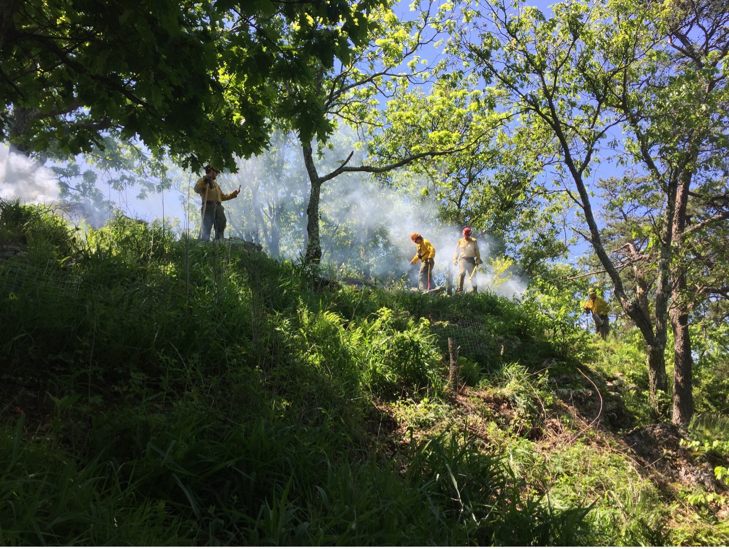
    A smoky prescribed fire on the crest of Peters Mountain in May 2017. Photo by Ryan Klopf.

    Population restoration

    These two lines of evidence – germination studies and fire history – suggested that a prescribed fire campaign would help reinvigorate the mallow population. A consortium of institutions rose to the challenge, including The Nature Conservancy and the Virginia Department of Conservation and Recreation. Burning the site was not easy. Fire crews hand-carried heavy tools, water, and drip torches off-trail up the side of the mountain. They created fire lines through steep, intact forest to prevent fire from spreading into the adjacent Jefferson National Forest.

    Initially, the ridgeline habitat was burned twice, once in 1992 and again in 1993. The return of fire led to a dramatic population increase as hundreds of seeds in the soil seed bank broke dormancy and germinated.

    In addition, the few remaining adult plants were caged to prevent wandering deer and other herbivores from eating them. Land managers removed trees, shrubs, and herbs with hand tools and herbicide to increase light availability. Two particular targets were white-flowered leafcup and garlic mustard (Alliaria petiolata) – an invasive species.

    As a further precaution, experimental populations were created offsite, including two at Virginia Tech. Some of the seeds from these garden plants were preserved frozen at the North Carolina Botanical Garden. Others were broadcast back into the habitat to await the next fire – and their opportunity to recruit into the population.

    In June 2004, lightning struck and a hot wildfire consumed the mountaintop. This conflagration followed two exceptionally dry years in which the Peters Mountain Mallow population failed to produce any fruits. The wildfire again stimulated germination of seeds in the soil seed bank, and a flush of mallows appeared over the next two years.

    Further burns in 2008, 2009, 2010, and 2011 assisted in growing the population from 74 individuals in 2005-2007 to an average of 110 individuals each year from 2012-2014. In May 2017, a multi-agency team burned the Peters Mountain Mallow habitat one last time. The vegetation was green, and the fire was smoky, but the population that year was robust. The team counted stems (an individual plant can have several) and found 345, down from 630 the year before. This was the last fire ignited on Peters Mountain before the COVID-19 outbreak. There has not been another one since.

    Reinvigorating research

    On a steamy morning in July 2024, a small group of ecologists, botanists, and land managers climbed the mountain to see how Peters Mountain Mallow was faring. One of us (Leighton) accompanied others from the Massey Herbarium, The Nature Conservancy, and the US Fish and Wildlife Service. What we found was disappointing. The mallow flowers we hoped to see were shriveled and dry from a prolonged drought. Worse, there were only a few of them. We did not do a thorough census, but this trip sparked the notion that the mallow required renewed attention.

    Drought-stressed flowers of Peters Mountain Mallow in summer 2024. Photo by Leighton Reid.

    For many years, researchers at Virginia Tech were heavily invested in this species – measuring the population, collecting seed, growing plants, performing genetic and physiological studies – even carrying jerry cans up the mountain to water plants during droughts. But this involvement waned as faculty retired and students moved on to other things. It seemed like a good time for a new wave of researchers to join the effort. Moreover, students in the newly-formed Ecological Restoration major had created a Society for Ecological Restoration student association (SER-VT) and were seeking a local project.

    Our first action was to formally survey the population. Last July, we laid out a transect to measure and map every individual. It did not take long. Since the last population inventory in 2018, the world’s only population of Peters Mountain Mallow has declined from 155 stems to just ten, representing only five individual plants. This is the same number of plants that there were when the species was first listed on the Endangered Species Act in 1986.

    What’s more, only two of the plants were large enough to produce flowers this year, and the flowering times were misaligned so that one plant was setting flower as the other was senescing. Peters Mountain Mallow requires cross-pollination, so no seeds were produced last year.

    While disappointing, this information is valuable for understanding the species’ boom-and-bust population dynamics and informing land managers about the acute need to bring fire back onto this landscape in the near future.

    Looking backwards to move ahead

    We know from the pine tree study that Peters Mountain burned frequently over the past two hundred years, but presumably the mallow has lived here for much longer. In what sort of environment did it evolve? Another undergraduate researcher, Nisha Polk, is using a different approach to construct an older, precolonial environmental history – and a potential reference for land managers to emulate.

    In October, Nisha climbed the mountain with Dr. Rachel Reid, a conservation paleoecologist in the Virginia Tech Geosciences Department. Nisha and Rachel inserted PVC tubes into the ground to collect soil cores from small pockets of earth between the boulders that make up the ridgetop. The soil is thin, no more than 25 cm, but it could contain organic matter from as much as 2,000 years ago.

    Over the next few months, Nisha will analyze the carbon isotopes from the soil organic matter to learn how old the soil is and what kinds of plants produced it. To age the soil, they will use carbon dating, which estimates when the soil was formed based on how much of the radioactive carbon-14 isotope is present. Then they will study the ratio of stable carbon-13 and carbon-12 isotopes to learn about past vegetation. In essence, lower ratios indicate plants that use a C3 photosynthetic pathway, including most broad-leaved plants that make up the temperate forests in our region, while higher ratios indicate plants that use a C4 photosynthetic pathway, such as warm-season grasses adapted to open grassland, savanna, and open woodland habitats. In other words, carbon isotopes can tell us what the predominant ecosystem was here over hundreds or thousands of years.

    Virginia Tech Ecological Restoration majors Nisha Polk (left) and Alex Owusu-Sampah (center) carefully collect a soil core on Peters Mountain with conservation paleoecologist Rachel Reid. Photo by Leighton Reid.

    A bright future?

    While Peters Mountain Mallow is again in the single digits worldwide, there are reasons for hope. First, the species produces a robust seed bank that may revitalize it when the site is next burned (hopefully soon). Second, the North Carolina Botanical Garden maintains a collection of its seeds – a back-up if the worst should happen. Third, the habitat is owned by The Nature Conservancy, whose land managers are committed to ensuring the species’ persistence. Fourth, the species is protected by the US Endangered Species Act, a 1973 law that is estimated to have prevented the extinction of more than 70 species.

    Finally, Virginians should have hope for the future of this botanical crown jewel because a new generation of undergraduate researchers is engaged, bringing fresh energy and insights to the cause, documenting the species’ ups and downs, and uncovering its natural history. Over the next five years, we envision an undergraduate-led research agenda that includes monitoring the mallow population, using paleoecology methods to learn about the long-term environmental history of the species’ habitat, and refining our understanding of its ecological niche.

    The New River cuts through Brush Mountain in southwest Virginia, just a bit upstream from Peters Mountain. Photo by Leighton Reid.
  • The hidden half of tropical forest recovery 

    The hidden half of tropical forest recovery 

    By Leland Werden

    Leland Werden, PhD, is a Senior Scientist at ETH Zurichlwerden@gmail.com

    I remember starting my PhD in 2012 with a strong desire to develop tools for recovering tropical forests around the world. My background was in ecosystem ecology, which had led me to spend time thinking about soil nutrient cycling and other belowground processes in different temperate forests across the Northeastern United States. What I didn’t realize at the time was that these forests were themselves an incredible regeneration success story.

    As agriculture moved westward to more suitable land between the 1870s and 1920s, New England farmers abandoned their fields and pastures, and forests naturally regenerated at scale. This century of intensive agriculture left a patchwork of land-use legacies that continued to influence forest composition and recovery in fascinating ways. I stumbled into this living laboratory as an undergraduate student at the Harvard Forest Long Term Ecological Research site, measuring forest recovery across this patchwork.

    One patch has stuck in my head since: a grove of the largest striped maples (Acer pensylvanicum) I’ve ever seen. Striped maple is typically an understory shrub that rarely reaches more than six meters (20 feet) tall. But in this tiny patch, about 20 individuals had ascended to the canopy and completely dominated the overstory. In chatting with one of the landscape ecologists on staff over lunch one day about this pattern, I learned that there used to be a farmstead there and the striped maples thrived on the elevated nutrients still present in the soil more than a century after the farm was abandoned.

    Despite having collected hundreds of soil cores in my life, sieved roots out of soil for months on end, and counted tiny soil fauna, I had never fully grasped how strongly soil type and land-use legacy could shape plant communities. That grove of striped maples taught me to look belowground to understand plant composition. Years later, when I began working in tropical forest restoration, some colleagues and I grew to understand that we were missing the same understanding on a large scale — focusing almost entirely on what grows aboveground while largely ignoring what happens beneath our feet when restoring tropical forests.

    This disconnect isn’t unique to tropical restoration. Across forest restoration projects worldwide, we count trees, measure canopy cover, and get excited to see the return of birds and dung beetles. These are important signs of recovery, but soils, roots, and the communities of organisms that live within are often overlooked. These living organisms drive water and nutrient cycling, contribute strongly to climate mitigation capacity, and also to long-term resilience that determine whether restored forests can withstand decades of droughts and other stresses to come.

    The recognition of this blind spot led some worlds to collide. A group of academics passionate about tropical root dynamics (TropiRoot) began to collaborate with multiple research groups working on restoration science across Europe, Latin America, tropical Africa, and the United States. Our core question was: How can resource-limited tropical forest restoration projects measure belowground recovery in a scientifically robust way? In the fall of 2023, my colleague Dr. Laura Toro and I, along with several others, started a working group to tackle this challenge. We met for three days in October of 2023 at the Yale School of the Environment and brainstormed a project that aimed to distill decades of research on soil science into priority indicators that capture the essence of soil recovery. 

    Our belowground restoration group meeting at Yale University and online in October 2023.

    A clear belowground monitoring gap 

    As we dug into global restoration monitoring frameworks and the scientific literature, the scope of this oversight became even clearer. A recent worldwide stocktake catalogued more than 4,500 indicators that restoration projects use to measure “success”. Of the 61 indicators chosen as highest priority, just one focused on belowground processes: soil carbon (Gann et al. 2022). Soil carbon is a notoriously difficult indicator to detect changes in, especially over the short timeframes most projects monitor.

    We then systematically reviewed almost 200 scientific studies on tropical forest restoration. Only 28 — fewer than one in seven — directly compared above and belowground properties at the same sites. Without these paired measurements, it’s really difficult to understand whether the recovering vegetation reflects holistic ecosystem recovery or if it might be masking soils struggling to recover from previous degradation.

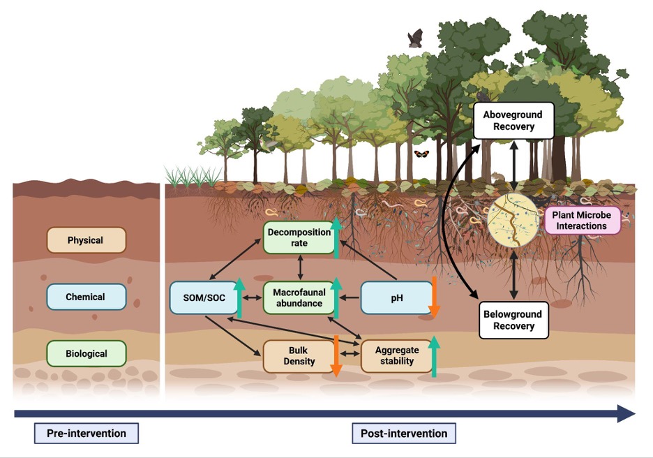
    The problem extends beyond academic research. When we surveyed restoration practitioners across 14 Latin American countries, we heard a similar story: projects typically have only resources to evaluate aboveground recovery, and often only for the first few years after planting. This is despite having ambitious goals of restoring entire ecosystem processes and recovering biodiversity (Cole and Werden et al. 2024).The appetite to track recovery holistically is there, but accessible tools and protocols often aren’t, so we developed a short list of six indicators and some rules of thumb for belowground monitoring, lowering the barrier to capture belowground recovery (Toro and Werden et al. 2025). We summarize the indicators below. 

    Six indicators to track belowground recovery 

    The strength of these indicators is their simplicity, paired with the ability to robustly summarize belowground recovery over time. Most indicators can be measured with equipment that can be purchased at a hardware store, or analyzed by a basic agricultural soil lab, and the priority indicators selected all change over timescales that matter for restoration

    Physical – 

    • Bulk density tells you how compacted the soil is – or how much soil is packed into a given space. When forests are cleared, machinery and/or grazing animals can compress the soil, making it hard for water to soak in and plant roots to penetrate. We measure this by pushing a metal cylinder of known volume into the soil, drying the sample in an oven, and dividing the dry weight by the cylinder’s volume. High bulk density means compacted soil; low bulk density means less dense, healthy soil with space for air and water that roots can grow into more easily.
    • Aggregate stability captures how well soil particles stick together in clumps, which determines whether rain soaks in or runs off, carrying topsoil with it. In the past, measuring this required laboratory equipment, but now there’s a smartphone app called SLAKES that guides you through the process. You simply just take photos of soil chunks before and after soaking them, and the app calculates an index of how well they held together.

    Chemical – 

    • Soil organic matter is often called the engine of soil fertility — decomposed plant and animal material that holds nutrients and water. It’s what gives soil its color and smell. When land is cleared and intensively used, the organic matter is often burned away or gets washed off. As forests regrow, leaves fall, roots die and decompose, and organic matter slowly builds back up. You can measure it by sending dried soil samples to a lab. 
    • Soil pH can be thought of as a whole bunch of soil chemistry compressed into a single number — it determines which nutrients plants can access. Low pH (acidic soils) can lock up nutrients and sometimes reach toxic levels of aluminum. You can test pH easily in the field by mixing soil with water and using a simple pH meter, or sending a sample to a lab. 

    Biological –  

    • Decomposition rate gives you a window into how active the soil’s living community is, all microbes that break down dead material and release nutrients for plants to use again. We suggest measuring this using “decomposition bags” — mesh bags filled with a standard amount of leaf litter (or even tea bags if available) that get buried in the soil and retrieved after a set time to see how much material decomposed. Faster decomposition usually means a healthier, more active soil community.
    • Macrofauna abundance is the count of larger soil animals such as earthworms, termites, beetle larvae, and others. These soil animals create tunnels that let water and air penetrate, mix organic matter through the soil layers, and their castings can contain  lots of incredibly fertile nutrients. To measure this, you dig a small trench, carefully sort through the soil and litter, and count all the macrofauna you find. It can take time, but these animals can be excellent indicators of soil recovery.
    From Toro and Werden et al. 2025 – Conceptual diagram of the importance of the status of soil properties pre-intervention in tropical forest restoration projects, and the six key dynamic soil indicators we suggest measuring. The black arrows represent known links among soil indicators and between soil properties and above- and belowground recovery processes. The color arrows indicate the expected direction of change: green arrows for increases and orange arrows for decreases. Recovery is also shaped by the reestablishment of plant-microbe interactions, which mediate feedback loops between vegetation and soil processes.

    A simple way to get started

    As part of our paper we also developed some recommendations for practitioners to start implementing belowground monitoring:

    • When to sample: Before restoration begins, set a baseline, then measure every 5 years or more frequently if possible. 
    • Where to sample: The top 10 cm of soil captures most early changes. 
    • How many samples: 5-10 cores per plot usually gives a reliable average. 
    • How to report: Use standard units so your data can be compared across sites and integrated into broader monitoring efforts. 
    • Other measurements: If you already measure above ground recovery indicators, keep doing that. Some aboveground patterns offer clues about what’s happening below, but in many cases, especially for soil carbon or microbial activity, what you see aboveground doesn’t tell the full story.

    Why below recovery matters for restoration

    Understanding soil recovery has immediate practical implications for understanding restoration outcomes. Healthy soils speed up seedling establishment, improve drought resistance, and support robust carbon storage that can make tropical forest restoration a viable natural climate solution. But soil recovery can also help projects make better management decisions in real time.

    If bulk density measurements reveal severe compaction, you could adjust your species selection to favor deep-rooted trees that can help break up hardpan layers. If organic matter is low, you could experiment with compost additions or mulching. But, without measuring this belowground information at the outset and as your project progresses, these management decisions can become educated guesswork.

    An invitation to what’s next

    Through the SNAPP Monitoring Restoration Effectiveness (MoRE) working group, we’re now building a collaborative network that connects researchers with practitioners on the ground. Among other things, our goal is to develop straightforward protocols for monitoring  belowground indicators. These protocols will be tested in real-world conditions and adapted based on feedback from practitioners. We’re also compiling longitudinal data from any tropical restoration project that has measured an indicator of below- or above-ground recovery for a global synthesis that aims to develop best practices for restoration monitoring.  

    If you’re working to refine your tropical soil monitoring practices, or if you just generally want to get involved, we’d love to hear from you. 

    Take our questionnaire on monitoring practices –  Here

    Learn more about our data synthesis –  On our website

    Get in touch with the SNAPP MoRE team –  snapp-more@umn.edu

  • Natural History and Ecological Restoration in the Madrean Mixed-Grass Prairie of Southeastern Arizona

    Natural History and Ecological Restoration in the Madrean Mixed-Grass Prairie of Southeastern Arizona

    By Matilda Essig

    Matilda Essig is an artist and agriculturalist who has lived in the grasslands of southeast Arizona since 2006. She uses visual art, hands-on restoration and public outreach to express the resilience of wild ecosystems. matilda@mindspring.com

    Blue grama. Digital capture, archival inkjet print by Matilda Essig. Unless otherwise indicated, all images are by the author.

    Nineteen years ago, I began a project to restore the native diversity of the grasslands on a badly damaged 5-acre residential parcel in southeast Arizona, in a region locally known as the Apache Highlands Grasslands, a.k.a. Madrean-Mixed Grass Prairie to botanists, naturalists and biogeographers. My journey was informed and inspired by landscape stewards throughout the American west – ranchers and conservation groups alike. My mission included restoring not just the amazing diversity of grasses in the region, but also using my experiences, expressed through the arts, to help restore the role of art as a visionary vehicle within our culture. Visual beauty, ecological, and spiritual beauty – we need to get in touch with all of them again.

    San Rafael Valley Overview. A monsoon cloud unleashes its fury over Saddle Mountain, headwaters of the Santa Cruz River.

    In 2008, I wrote an article for Ecological Restoration, with my friend, and then-editor Mrill Ingram, wherein I described the conditions and biological makeup of my land. This article, Portraits of Grasses, gave an in-depth description of the biological ingredients I had to begin with, and also the artistic process I learned to use to make direct images from nature, using digital technology.
    At the invitation of my friend James Aronson, I am delighted to share an update here, in NHER, mentioning the methods that worked and failed, and highlighting  native grass species, and sharing how my portraits of these grasses engaged new audiences. What I have borne witness to in my brief tenure as an artist and restoration steward on my small tract of land has given rise to meaningful dialogue across the spectrum of possible audiences, through exhibitions, residencies, studio visits, and the artist’s book that I produced, Native Grasses of the Apache Highlands, which is now available for use in five university library special collections.

    Suite of five grasses. Blue grama (Bouteloua gracilis), Hairy grama (Bouteloua hirsuta), Little bluestem (Schizachrium scoparium), Sideoats grama (Bouteloua curtipendula), and Rothrock’s grama (Bouteloua barbata var. rothrockii). Digital capture, archival inkjet prints.

    The Apache Highlands grasslands – also known as the Madrean Mixed-Grass Prairie, which derives its name from The Madrean floristic region (named after the Sierra Madre Occidental) that occupies the arid and semiarid areas in the southwestern US and northwestern Mexico, at the northern edge of the subtropics. Sandwiched between huge basins and the rocky mountains, it’s a biodiversity hotspot. The summer monsoon delivers the most annual precipitation and is the primary (warm) growing season for the grasses. The San Rafael valley, which spans the US/Mexico border, is home to the southwestern-most intact stand of Shortgrass prairie in North America.

    The Apache Highlands Ecoregion, X marks Matilda’s property. Map by Robert Bailey, The Nature Conservancy.

    According to the late, great desert ecologist Tony Burgess, who passed away in 2022, these were the most characteristic native grasses in my region: Black grama Bouteloua eriopoda, Blue grama, Curly-mesquite grass – Hilaria belangeri, Vine-mesquite grass – Panicum obtusum, Cane beardgrass – Bothriochloa barbinodis, Purple threeawn – Aristida purpurea, Poverty three-awn grass – Aristida divaricata, Plains lovegrass – Eragrostis intermedia, Giant sacaton – Sporobolus wrightii and Arizona cottontop – Digitaria californica

    Over the years, I’ve come to recognize many more grasses, some of which I’ll mention below. Sadly, a plethora of invasive grasses and other plants now compete with the natives on my property which is in a subdivision carved out of what was, until quite recently, open grassland.

    Sideoats grama. Digital capture, archival inkjet print.

    The slope is gently north facing, with the buildings situated on the flat area of the ridgetop in the SE corner of my 5-acre property. It has fenced pastures which had been overgrazed by an equine for 20 years, resulting in an abundance of amaranths (Amaranthus spp.) and various kinds of ‘tumbleweeds’ including Salsola spp. (Chenopodiaceae). 

    Among the invasive grasses I had to deal with were Johnson grass (Sorghum halepense), and Lehmann’s love grass (Eragrostis lehmanniana), Yellow bluestem grass (Bothriochloa ischaemum), and the infamous, cosmopolitan weed Skutch grass or Bermuda grass (Cynodon dactylon) that had been planted by previous owners for lawn and equine grazing. My first steps to control the invasives, and promote recovery of the pre-existing flora and vegetation, began with cattle and rotational grazing practices that I learned from neighbors. That was quite successful in knocking back the swarms of amaranths at the start of the monsoonal growing season, thereby allowing the slow-growing grasses to gain a foothold. While I had wanted to work with goats in subsequent years, I chose not to undertake the labor-intensive fencing that would be required to control them and their voracious grazing habits. The cattle had been easy to contain with single strand aluminum wire and a solar charged battery for electricity.

    Five borrowed cattle – a British white park bull, and four criollo heifers – feasting on amaranth and other invasives at the start of the rains and growing season, early July.

    Instead, I invested in a high-quality mower and did a lot of pulling by hand of all the invasive species that I could. In the first few years, my progress was great – eliminating the amaranth completely around the buildings and well into the pastures, and completely extirpating the tumbleweeds, without any chemical assistance. Instead, I set out to learn about the root strengths and soil moisture of each invader species, so as to be able to pull each plant at the most appropriate moment in order to remove the entire root system with minimal soil disturbance. Working to reduce the invasives, I also learned about the natives, as I watched them rebound in the absence of competition.

    Sensing and observing the effects of my role as a player in this ecological equation gave me great inspiration for creating the artworks – to celebrate the grass species that I was learning about, and to share the story of healing the landscape. By healing, I mean restoring the native grasses which I knew, in turn, would be nourishing soil health and ecosystem health. 

    The Grasses

    Out of the more than 100 native Poaceae in the Apache Highlands, the most prevalent and iconic is Blue grama, a recognized keystone species and, now, a keystone also in the communications programs based on my artwork. It was the favorite of my first local mentor, senior rancher John Donaldson, who first taught me about the role of grasses in assisting the recovery of soil and watershed health on the nearby Empire Ranch, now the Las Cienegas National Conservation Area. This species has persisted and rebounded from the impacts of overgrazing on my property, and is notably much beloved throughout the interior western USA and northern Mexico, for its role  as a pillar of many kinds of grassland communities, and because it is palatable and provides high protein content for feed for livestock.

    I had immediate success in portraying the character of this species, and through the strong imagery, it served as a common denominator in rangeland discussion amongst the agricultural communities with whom I met at conferences. In particular, the Quivira Coalition’s 2009 conference on the theme of American conservationist Aldo Leopold was a great opportunity to engage in the dialogue about the role of beauty in land conservation. As I mentioned above, visual beauty, ecological beauty and spiritual beauty are all players, so to speak, in the determination of future land usage decisions based on human values. Sideoats grama, Rothrock’s grama, and Hairy grama were all present and easy to portray, with their vertical postures and  showy inflorescence, but Black grama was a far greater challenge to find and portray, with tiny its slivers of seed head, and prostate growth patterns.

    Black grama. Digital capture, archival inkjet print.

    I’d searched for this species after hearing Brandon Bestlemeyer, ecologist and research leader at the Jornada Experimental Range, describe it as a critical species in the future of grasslands conservation. Many such inspiring collaborative conversations came about in the context of annual science meetings convened by the Malpai Borderlands Group, whose legendary accomplishments in bringing ranchers and conservationists together have resulted in biological protection for vast tracts of open range grasslands in the Chihuahuan desert. My friend Ben Wilder, a biogeographer and communicator with the Next Generation Sonoran Desert Researchers, chose the image of Black grama to draw an audience for a fundraising event for the UA Herbarium and the vast resource of its collections. The image spoke to them about spirit and resilience.

    While my original focus had been to learn everything I could about how and where the individual grasses grow, the point of understanding multiple species was to illuminate the strength that biodiversity creates within the fabric of ecological communities. When the Land Institute, the Kansas-based agricultural research organization working to develop sustainable food crops, invited me to present as Artist for the 30th annual Prairie Festival (2010), they wanted an image for the theme of perennial polyculture. This challenged me to portray a group portrait that was inspired by a series that I collected, just as it occurred, from a pasture of a neighboring rancher, Rukin Jelks, who practiced holistic management methods: a mature rotational cell system designed byAlan Savory thirty years ago.

    Perennial Polyculture. Hairy grama, Plains lovegrass, Sideoats grama, Poverty three-awn, Bristle wolf’s-tail (Lycurus setosus), and the naturalized Afghani bluestem (Bothriochloa bladhii). Digital capture, archival inkjet print.

    The Audiences 

    The audiences at conservation meetings and the Prairie Festival knew the subject and shared my love for it. I believe they even felt their passion for land and prairie conservation was being recognized and honored in a new way. At traditional art venues —museums and galleries —the subject matter was largely novel, reaching audiences in different, more intuitive ways. The resounding response was, ‘I will never look at grasslands the same way again’. The diversity of plant characters also brought out the diversity in my audience:  some viewers related to chaotic images like Tanglehead grass (Heteropogon contortus) whereas others were repelled by it.

    Tanglehead grass. Digital capture, archival inkjet print.

    The audiences of the fine art world were ripe for the authenticity of nature based values, a light of climate change and then the pandemic. At Tucson Museum of Art, (2013) I worked with the curator to produce a large group exhibition called “Desert Grasslands”, which offered side events such as art-science panel talks about rangeland conservation, Buffelgrass (Pennisetum ciliareformerly calledCenchrus ciliaris),  the noxious and highly flammable invasive that now threatens the Sonoran desert. 
    At the Amerind Museum, I had a solo show for Native Grasses of the Apache Highlands,(2016) and was able to engage with Hopi and Navajo tribal members in a shared sense of spiritual and creative source in the natural world. At the Willa Cather Foundation my solo show focused on comparing the prairie grass characters to Cather’s meticulous human portraits of pioneer immigrants – studies in adaptation and resilience. At the Tucson Airports’ Center Gallery, in 2019, I was able to offer the work to the broadest audience yet, and also use the setting to meet with visiting classical composer Emerson Eads to discuss collaborative musical intentions, and also Indigenous author and botanist Robin Wall Kimmerer.

    Over Time

    While an extreme weather event in 2021 – 3 inches (75 mm) of rain in one hour – reversed years’ of hard work in a single episode, leading to the germination of an ‘avalanche’ of amaranth seed that had likely lain dormant for more than a decade, the subsequent two years of sustained drought allowed a favorite native grass of mine to appear – Sand dropseed (Sporobolus cryptandrus)- in uncanny abundance. Additionally, as I grew to learn the songs of grassland birds, my restoration priorities expanded to include the habitats of the avian species that also thrived from my work, Meadowlark and Scaled quail in particular.  The meadowlark’s song is both ancient and evolving in this landscape, as we have eastern, western, and also a new Chihuahuan subspecies recently identified by its song. The invasive plants have also inspired their own folio, currently underway.

    In conclusion,  my intentions moving forward are to work with the folios in university settings, to challenge our culture-driven perceptual paradigms of the natural world, engaging the next generation with the inspiration of stewardship thinking, both from conceptual understanding through the stories of these many land managers, and also to inspire them to see their own potential hand in the process, to experience the role of healer, and to know that no matter how small or large a parcel or landholding they may be working on, five acres or fifty thousand, every gesture makes a difference. To that end, I look forward to further opportunities to collaborate with EHN and its partners, to help inspire acts of ecological restoration, and to offer the arts as a catalyst for all.

    Matilda on Flecha, looking north across the San Rafael Valley, headwaters to the Santa Cruz river. Saddle Mountain and the Santa Rita Mountains in the background. Photo by Zay Hartigan.

    I would like to express my gratitude to James Aronson and Lauren Shew for editorial and technical assistance in creating this post.

  • ACCIÓN SERRANA Network: Conserving and restoring cloud forests in the mountains of Córdoba  province, central Argentina.

    ACCIÓN SERRANA Network: Conserving and restoring cloud forests in the mountains of Córdoba  province, central Argentina.

    By: Pablo Friedlander and Romina Torre

    Dr. Pablo Friedlander, Director of Acción Serrana has initiated and led pioneering restoration and intercultural education projects in Argentina, Brazil and Spain for more than two decades. He also organizes ethnobotanical research and expeditions to the Amazon and the Andes. pablofriedlander@gmail.com

    Biologist Romina Torre is the executive coordinator of Acción Serrana, with ten years of  experience in mountain restoration, research and educational activities involving rural communities, health practitioners and scientific institutions at bioregional and international levels. torre.romina@gmail.com

    Introduction to the Polylepis forests

    In the highest mountains of South America, remnants of vast stands of so-called cloud forests dominated by members of the beautiful Rose-family genus Polylepis are found throughout the Andes Cordillera, from Colombia and Venezuela to northern Chile and northwestern Argentina. In addition, in the much older Sierras Grandes de Córdoba, in central Argentina, the endemic Polylepis australis (locally known as Tabaquillo), occurs in scattered fragments of once extensive mid-altitude forests. At the continental scale, the canopies of these open, moist formations,  or what remains of them today, comprise 45 recognized species and constitute the highest altitude forests on Earth (Boza Espinoza & Kessler 2022). Sadly, their range and integrity has been drastically reduced by logging, burning, and overgrazing since the 16th century, especially with the introduction of European cattle.Their moss- and lichen-covered branches collect fog, while their roots prevent erosion and regulate water runoff. These forests also contribute to climate change mitigation,  by favoring carbon sequestration, and they support diverse endangered species dependent on these habitats. In all seven of the Andean countries where they occur, the restoration and conservation of these cloud forests is of vital importance to local communities and to protect. the headwaters of the main rivers and creeks (del Campo & Friedländer 2023).

    This locally famous ‘Grandfather’ Tabaquillo (Polylepis australis) tree grows in the heart of one of the last remaining cloud forest fragments in Córdoba  province.
    The Argentina anole, Pristidactylus achalensis, is an endemic lizard of the Pampa de Achala.

    The hand-shaped Polylepis leaves and the soft, multi-layered bark of the trees, draped with epiphytes, mosses and lichens, collect fog and give rise to the compelling and accurate image of the forest “milking” the omnipresent mist and clouds. At a continental scale, these cloud forests when they are healthy and thriving contribute to the ‘biotic pump’ connecting the Andes- the Amazon-and the Atlantic Forest biomes (Beveridge et al. 2024) and regulating water and climate cycles and  reducing the risk and severitry of wildfires. The savannas and cloud forests The recent increase of forest fires in all biomes of South – and Meso- and North America – demands more strategic and intercultural, public-private coalitions to increase restoration areas and protection of basins at multiple spatial scales for present and future generations (Argañaraz et al. 2015; Argibay & Renison 2018). Additionally, Polylepis roots and their mutualistic microorganisms retain and enrich soils. They also provide a ‘framework’ for regenerating forest communities undergoing active or assisted restoration. Indeed, when mature, these emblematic forests harbour very high biodiversity, including many endemic species of epiphytic orchids, insects, birds and reptiles, and also provide a wide range of ecosystem services to people at multiple spatial scales. Finally, they have huge cultural significance, and by working in synergy with local communities we aim to introduce and sustain biocultural as well as ecological restoration.

    Conserving and Restoring the cloud forests with Acción Serrana and Acción Andina

    In 2002, the project “Milking the Clouds” (Ordeñando Nubes, in Spanish) was launched, along with other local grassroots initiatives. Then, after a long learning curve in restoration methods and typical pioneering struggles, the five interrelated projects gradually scaled up their ‘footprint’ and their impact to a bioregional level over the next decade and a half. A big step was taken in 2018 when, together with the ECOAN (Asociación Ecosistemas Andinos) and Global Forest Generation, Acción Serrana was set up as a hub including 5 different local organizations to help in the launching of  “Acción Andina” as a a new international ecocultural restoration consortium. In that context, Acción Serrana is now managed by the Fundación de Actividades Biosféricas as part of Acción Andina

    Currently working in Peru, Ecuador, Colombia, Bolivia, Chile and Argentina, with 23 member institutions, Acción Andina partners have planted more than 7 million Polylepis trees, of many different species, and this number is rising each year, as is the success rate of the plantings. In 2023, Accion Andina received the prestigious Earthshot Prize, and in 2024 we were named one of the 7 UN World Restoration Flagships for the UN Decade on Ecosystem Restoration 2021-2030

    Map of the 12 Acción Serrana restoration sites in the Sierras Grandes de Córdoba.

    The 12 biocultural restoration areas in the Sierras Grandes of Córdoba under Acción Serrana management add up, at the time of writing, to a total of 3,170 fenced hectares. 

    The reforestation and restoration campaigns are made possible by 65 permanent staff members and over 1,500 volunteers per year on average. To date, we have produced and planted more than 860, 000 Polylepis australis nursery-grown saplings in consecutive seasons (see https://ecohealthglobal.org/network-sites/accion-serrana-argentina/). All of these trees were grown from seeds collected locally in each of the planting areas managed by the five different partnering organizations or local implementing groups  For the 2024-2025 October 2024 to March 2025 planting season, 250,000 trees were propagated in the 29 plant nurseries we maintain, and at the time of writing most of the plantings have been very successful. Since 2023, Accion Serrana has been helping to replicate the same initiative in Northwestern Argentina, with the Project Arbol y Vida in Jujuy Province (in cooperation with various high-Andean communities) and the Germinar Project in Tucuman Province (working with Diaguita communities of the Tafi del Valle bioregion), advising on and synergizing actions and application of  techniques and strategies. In addition to this biocultural restoration, another critical line of work is our environmental education program being run in local schools and municipalities for more than a decade already.

    The ecosystems of Acción Serrana are Sub-Andean and Chaco serrano forests and grasslands (sensu Cabrera 1976), composed of seasonally dry forests or open woodlands with 4 different altitudinal belts in the central Argentina mountain ranges, Sierras Grandes de Córdoba (Giorgis et al. 2011). The land tenure of the areas under restoration inside the Provincial Watershed Reserve of Pampa de Achala, which consists of private landholdings subject to Provincial Management & Conservation plans, or  public protected áreas within the National Park Quebrada del Condorito. The numerous activities we carry out include: maintenance and fencing of new areas, native forest tree and shrub seed collection, construction and improvements of nurseries, germination of seedlings, transplanting of seedlings to reusable plastic forest tubes, high mountain transfer of seedlings to the planting areas and their planting in the intervention areas during the rainy season. We establish permanent plots for scientific monitoring and we support research carried out in the intervention areas. Workshops, public talks and training programs are also organized yearly to train and recruit more enthusiastic and qualified citizen restorationists for the work in the mountains.

    Acción Serrana team planting the native Polylepis australis of Córdoba province.

    Implementation of Acción Serrana with local partners in reciprocity

    We work to  generate ecological, economic, social and cultural sustainability by reaching agreements with landowners, communities, networks and institutions (municipalities of Mina Clavero and Villa de Las Rosas, the Ministry of Education of the Province of Córdoba, and others). 

    To help with the local matching needed to be part of the Acción Andina  initiative, Acción Serrana had set up the Ayni Plan (“ayni” meaning “reciprocity” in the quechua language of the Andes). Basically this implies the commitment to generate 30% of operating costs through specific fundraising campaigns and by other quantified means. For example the constant one of inviting the public to participate by donations of the costs required for producing a forest (25 trees under monitoring), a tree or a volunteering activity. Then we promote the reception of donations of funds, lands, tools, materials, vehicles, etc.. In addition, we encourage ecotourism with a schedule for each area: summer plantations and seeds, winter transplanting of seedlings and fencing of restoration areas. Acción Serrana aims to increase reciprocity and abundance also throughout the different courses and events both virtual and in-person, and some special community parties, with raffles, concerts, talks, video screenings, and promotion of crowdfunding campaigns. Currently we are running our international matching crowdfunder campaign with the help of the Treeangle Foundation from the United Kingdom, as we have done each year from 2012, to complete the mission of this season January 2024 – March 2025. (See video here.)

    In the years ahead, Acción Serrana will propagate and plant a wider variety of native trees and shrubs in pursuit of a Framework species approach to restoration such as that being tested by EHN partner Daniel Perez and his team in Caviahue, Patagonia (Perez et al. 2019; see also here and (here). As a new initiative, we aim to  deploy 30% of funds raised to reintroduction of multipurpose Neltuma (formerly Prosopis) species and other framework species in lower altitudes of the mountain system, and 70% to ongoing Polylepis restoration in the high mountains. This year, we have begun studying how to propagate the obvious additional choices of “framework species” namely Maiten (Maytenus boaria), Escalonia (Escallonia cordobensis) and Molle (Lithraea molleoides)

    Escallonia cordobensis a formerly common shrub now considered key to restoration.
    Co-dominant Maytenus boaria and Polylepis australis ‘giants’.

    Next steps

    Following decades of reforestation and cloud forest restoration, we are working with Indigenous inhabitants in these mountains, including the Comechingones (Henia and Camiare tribes) and Sanavirones peoples, who have been historically marginalized. We are cultivating intercultural bridges (Rojas et al. 2025) in áreas like nursery propagation, environmental education, and llama and alpaca reintroduction and ancestral practices of weaving with camelid wool. This collaborative framework aims to integrate and restore  key zones around the Ansenuza Sea, Traslasierra Valley, Pampa Achala, and Pampa de Pocho. 

    In January 2025, Acción Serrana became a new member hub of the Ecological Health Network, following two fruitful visits from James Aronson. These visits facilitated knowledge sharing and collaboration, furthering our core purpose of scaling up watershed restoration, enhancing environmental education, and deepening intercultural collaboration for research projects. By integrating ecological, social, and economic perspectives and approaches, we aim to share our regenerative experiences across mountains, jungles, deserts and oceans within a quickly growing international network of networks. We are delighted to be part of this movement and consortium with a strong, clear set of values and shared purpose  – something we all need to cultivate in these critical times. As a meaningful next step of Acción Serrana, we look forward to participating in multi-site research projects based on the simultaneous monitoring and evaluation of a series of ecological and human health indicators in areas undergoing biocultural restoration protocols. Through these efforts, we are committed to enhancing ecosystem health and strengthening our relationship with nature, ensuring the longevity and health of Andean cloud forests and lower buffer zones of Chaco serrano forests -as well as the local communities living there for generations to come. 

    Learn more by watching these videos on Acción Serrana and the Biodiversity in Sierras Grandes de Córdoba.

    All images are from the archives of Acción Serrana.

  • Understanding the role of soil microbial communities in oak woodland restoration using DNA metabarcoding

    Understanding the role of soil microbial communities in oak woodland restoration using DNA metabarcoding

    By: Rachel Brant

    Rachel is a postdoctoral fellow in the Missouri Botanical Garden’s Center for Conservation & Sustainable Development whose research focuses on plant-pollinator interactions and using eDNA to advance the conservation and restoration of biodiversity.

    Oak-dominated ecosystems occur in many areas of the northern hemisphere, support considerable biodiversity, and provide vast benefits to humans. Although notably absent from the southern hemisphere, oak-dominated or mixed-oak dominated forests are found across much of southern and central Europe, northeast Asia, and the eastern and central United States. Oak ecosystems range from closed forests with a dense midstory to open forests or woodlands with continuous canopy or widely spaced trees and dominance of herbaceous vegetation in the understory.

    Around 80% or more of the plant diversity in oak forest and woodland ecosystems in the eastern US, including a large proportion of rare species, resides in the herbaceous layer, which contributes significantly to nutrient cycling and overall ecosystem function. However, these forests and woodlands have suffered significant degradation over the past century, resulting in dramatic shifts in species composition and structure due to human land-use activities, invasive species, and alterations in disturbance regimes. In particular, fire exclusion has led to the encroachment of fire-intolerant tree species and nonnative shrubs, decreasing both understory light availability and the abundance and diversity of herbaceous plant species.

    Restoration of oak ecosystems usually involves prescribed burning or a combination of burning, canopy thinning, and control of undesirable woody vegetation. Although these restorative practices encourage the passive recovery of herbaceous flora, restored oak woodlands often lack conservative species in the understory. Unlike matrix or ruderal plant species, conservative plant species are those that depend on high-quality or minimally damaged sites and rapidly disappear with degradation. In addition, they often fail to recolonize sites naturally, making them potentially important targets for reintroduction.

    (Top) Degraded oak woodland at Missouri Botanical Garden’s Shaw Nature Reserve infested with nonnative shrubs and fire-sensitive tree species and (Bottom) Adjacent restored oak woodland after mechanical control of woody encroachment and six prescribed burns. Note the minimal sunlight penetrating the woodland floor and lack of herbaceous species in the degraded woodland relative to the restored woodland. Photo: (Top) Brad Delfeld and (Bottom) Matthew Albrecht.

    Conservative species are notoriously challenging to reintroduce in restoration projects, with soil microbes emerging as a key factor influencing their success. Arbuscular mycorrhizal fungi (AMF) are particularly crucial in this context; they enhance nutrient uptake and improve stress resistance, benefits that are especially valuable for conservative plant species with specific habitat requirements. For example, one study found that conservative species were more dependent on AMF and exhibited higher habitat specificity compared to less conservative species (Bauer et al. 2018). The practice of soil inoculation with whole soil, which presumably contains beneficial mutualists like AMF, is increasingly employed to boost plant growth and survival in restoration projects. Despite its growing popularity, though, the effects of soil inoculation on the establishment of herbaceous species in oak-dominated ecosystems remain poorly tested.

    Another factor that may affect the establishment of conservative plant species is the timing of reintroduction. Environmental conditions are predicted to be more favorable for the establishment of conservative species later in restoration, in part because soil symbionts facilitating plant establishment may only be found in later-successional sites. Alternatively, early restorations may lack the establishment barriers potentially encountered later in restoration, such as competition with established vegetation or soil legacies from early-arriving species, but could be deficient in important microbial mutualists often required by conservative plant species.

    To test these hypotheses, we examined the potential role of soil microbial communities on the performance of conservative herbaceous species using an oak woodland restoration chronosequence at the Missouri Botanical Garden’s Shaw Nature Reserve. First, we collected bulked field soil samples from three sites representing different restoration ages (young, intermediate, and old) based on their onset since restoration began (7, 16, 29 years ago) with prescribed burning, selective tree thinning, and non-native shrub control. We quantified several soil abiotic properties (e.g., pH, phosphorus, potassium, and nitrogen) and employed DNA metabarcoding to describe the microbial composition of the soil. DNA metabarcoding is a cutting-edge technique that identifies many taxa from an environmental sample by sequencing specific genetic markers from extracted DNA. This method provides a comprehensive snapshot of the microbial diversity present, allowing one to better understand otherwise cryptic below ground communities. 

    Conservative perennial forbs used in a greenhouse study to test the effects of soil inoculation young, intermediate, and old restored woodlands on plant growth: Geum virginianum (left), Solidago argute (center), and Solidago caesia (right). Photo credit: Gerrit Davidse (left) and Missouri Botanical Garden (center and right).

    Next, we conducted a greenhouse study with three conservative forb species, Geum virginianum, Solidago arguta, and Solidago caesia, testing their growth responses to soil inoculum from sites that differ in restoration age. These species are components of the regional species pool, but absent from restored oak woodlands at Shaw Nature Reserve. We placed germinated seeds of each species in quart-sized pots filled with a sterilized topsoil mix that mimic oak woodland soils. Each sterile pot (270 in total) was then inoculated with 10 mL of the bulked live field soil (approx. 1% by volume) sourced from one of the three restored sites. Plants were grown for 12 weeks in standard greenhouse conditions and then evaluated for growth using nondestructive measurements.

    Planting seeds of conservative forb species into soil inoculum treatments in a greenhouse study. Photo credit: Leighton Reid

    Tree species and soil microbial communities in restored oak woodlands 
    Not surprisingly, we found that younger restored oak woodlands, with historically fewer prescribed fires, had a greater abundance of fire-sensitive tree species (e.g., sugar maple, Acer saccharum) than the intermediate and older restored sites. However, younger restored woodlands also exhibited lower levels of soil phosphorus compared to older sites, consistent with previous studies that have shown greater levels of potassium and phosphorus in soils post-burning. Other soil abiotic properties, however, did not differ across the restoration chronosequence. 

    A grove of sugar maples (Acer saccharum) during autumn in the young restoration site at Shaw Nature Reserve. Photo credit: Mike Saxton

    Bacterial and fungal communities varied in composition across the restoration chronosequence. For example, Firmicutes, a phylum of bacteria noted for surviving in extreme conditions, such as in severely burned areas, was more abundant in soils from the oldest restored woodland, which experienced a greater number of prescribed fires than the other sites. In contrast, the fungal phylum Ascomycota was more abundant in restored woodlands of young and intermediate age. Members of Ascomycota include decomposers that break down organic materials and endophytes that form mutualistic or commensal associations with plants. 

    Plant-soil interactions in response to soil inoculation
    After 12 weeks of plant growth in the greenhouse, we found that forbs tended to grow larger leaves when grown in soil inoculum from the younger restoration site compared to the intermediate restoration site. Additionally, S. arguta and S. caesia grew longer leaves in soil inoculated from the intermediate compared to the old site, while G. virginianum plants tended to produce longer leaves when grown in inoculum from young relative to the old restoration site.

    Leaf length (cm) of three native forbs after 12 weeks of growth in whole-soil inoculations from young, intermediate, and old restored oak woodlands at Shaw Nature Reserve. Geum virginianum (GV), Solidago arguta (SA), and Solidago caesia (SC).

    Results from the DNA metabarcoding provide a clue as to why the soil inoculum treatments induced different plant-growth responses. Soils from the young restoration exhibited increased relative abundance of mutualistic microbes, including AMF and cyanobacteria, and decreased pathogenic taxa after conditioning by each of the three species. In contrast, the oldest restoration site had the greatest relative abundance of pathogens and the lowest relative abundance of mutualists. This enhanced microbial profile in young restorations may facilitate better nutrient uptake, and disease and stress resistance in plants. From a practical perspective, early-stage restorations may provide the most favorable soil microbial community for the establishment of conservative plant species in these oak ecosystems. One possible reason for this could be a shift in the increased relative abundance of AMF-associating tree species (e.g., maple) from older to young restored woodlands. AMF-associating tree species may harbor unique AMF taxa that resulted in increased herbaceous plant growth and AMF colonization for plants conditioned with young soil inoculum.

    Interestingly, although some microbial taxa exhibited consistent patterns across all plant species within an inoculation treatment, each plant species also associated with unique microbial taxa when grown in the same soil inoculum treatment. For example, the Glomeraceae, which includes AMF, was marginally more abundant after S. caesia was grown in young inoculum, whereas Ascobolaceae – fungi that feed on decaying and dead matter – was significantly abundant only when G. virginianum was grown in old soil inoculum. This means that species reintroduced during different stages of oak ecosystem restoration could influence key ecological functions by selecting for or against certain microbes, including pathogens that regulate plant community dynamics, decomposers involved in nutrient cycling, and mutualists that enhance plant performance. 

    Overall, our study demonstrates how restoration age can shape interactions between soil microbes and herbaceous plant species in restored oak woodlands. By better understanding these interactions, we can enhance the restoration and recovery of degraded oak ecosystems. However, an important and lingering question from our study is whether differences in plant growth and microbial communities observed in the greenhouse persist after the focal plant species are transplanted into the field. A study currently underway at Shaw Nature Reserve is addressing this question across different restoration ages and competition treatments. Our study reinforces global calls that emphasize the need for more research on the dynamic nature of plant-microbe relationships and interactions over time during restoration. Advancing scientific research on the relationship between the soil microbiota and ecological restoration practices is crucial for meeting local, regional, biome level and global restoration goals.

    If you want to learn more about microbial-herbaceous plant interactions in restored oak woodland, we invite you to read our recent paper in Ecology and Evolution.

  • Identifying regional and restoration species pools for the Ozark Highlands

    Identifying regional and restoration species pools for the Ozark Highlands

    Andrew Kaul is a Restoration Ecology Post-doc in the Center for Conservation and Sustainable Development working with Matthew Albrecht at the Missouri Botanical Garden, and Michael Barash is a junior Biology major at Washington University in St. Louis. Here they describe Michael’s undergraduate research on commercial native seed availability for woodland restoration.

    One of the largest barriers to restoration of degraded terrestrial habitats is availability of seed for use in reintroduction of desirable native plant species. Over the past few decades, the industry of native plant seed production has grown rapidly, but most native species in the US (and globally) are still not commercially available, and there can be strong biases in which types of species tend to be selected by seed producers.

    In ecological parlance, a “species pool” represents all of the species which can colonize and occupy a certain region. Not all of the species in a regional species pool are available commercially, which is how many restoration practitioners acquire seeds, so the subset of species pool that contains only the species that are commercially available in a given region is sometimes called the “restoration species pool”.

    For most ecosystems around the world, it is not well documented what proportion of the species pool is commercially available, and why these species have been selected for commercial trade. The few studies that have been conducted on commercial seed availability for restoration have found consistently that herbaceous (rather than woody) and rare species (rather than common ones) are less likely to be available, and there are strong taxonomic biases in which plant families are more represented. In the US, these studies have focused on open-canopy habitats with few trees, such as grasslands, rather than on more closed-canopy systems like woodlands and forests.

    An open rocky glade (left), and a glade to woodland transition (middle), a woodland understory (right; Shaw Nature Reserve, Gray summit MO).

    To address this information gap, we assessed the capacity of the native seed industry to support ecological restoration across terrestrial habitats in the Ozark region of the midcontinent USA. The use of seed additions to accelerate recovery of plant diversity in Ozark woodlands and forests is not well studied, and little information is available on how to best select species for reintroduction from seed. The specific goals of this project were to:

    1) Identify the species pool of native herbaceous (non-woody) vascular plants appropriate for restoration of glades, woodlands, and forests in the Ozark Highlands;

    2) Define the restoration species pool by identifying which of these species are commercially available;

    3) Quantify biases in this restoration species pool with respect to growth form, rarity, habitat affinity, and a few important functional traits;

    4) Identify candidate species which are not available from seed vendors, but should be a priority for seed production due to their importance for Ozark habitats.

    The spatial scope of this study is the Ozark Highlands, level III ecoregion 39, which covers all of Southern Missouri, as well as parts of Northern Arkansas, and NE Oklahoma.

    We began this project by developing a targeted species list of 1,178 herbaceous species native to upland habitats in the Ozark region, based on existing datasets from the Ecological Checklist of the Missouri Flora, the Flora of Missouri, and the Biota of North America Program (BONAP).

    We predicted there would be selection, implicit or explicitly, by seed producers for species based on their growth form, conservatism score wetness rating, rarity, and functional traits. Each species’ physiognomy (growth form), conservatism score (that is, sensitivity to disturbance), and wetness ratings (a type of habitat affinity) were included in the Missouri Checklist. For each species in our pool, we compiled data on two measures of rarity including a qualitative measure –  the official Missouri State conservation ranking, and a quantitative measure – the range size of the species in the US, as measured by the number counties in the nation where there have been recorded occurrences in the BONAP database. We compiled trait data on height of adult plants, and bloom timing and duration from species descriptions in the Flora of Missouri. For each grass species, we compiled data on photosynthetic pathway from published literature.

    We made predictions that species with certain growth strategies, traits, range sizes, and habitat preferences would be under- or over-represented in the pool of species produced by seed vendors. We predicted that compared to other growth forms, perennial forbs would be over-represented in the restoration species pool because the aesthetic value of restoration projects is often a high priority, and perennial forbs with their big flowers, are “showier” and will return year after year. Similarly, taller species, and those with a longer bloom period may be selected preferentially because their blooms are more noticeable. We expected that species which have a smaller range or are not abundant in sites where they do occur are less likely to be in demand by restoration practitioners, so are less likely to be commercially available. Based on this pattern we expected species with a lower conservatism score, larger range size, and higher conservation rank (less concern for conservation) to be more commonly produced by seed vendors.

    We predicted that species with a larger range such as pale purple coneflower (Echinacea pallida; map on the left), would be more likely to be available from at least one producer than species with a smaller range, such as the related yellow coneflower (Echinacea paradoxa; right). Maps are from BONAP, and light green areas denote counties where the species has been reported.

    The cottage seed industry for prairie plants has grown especially rapidly in recent years, so we expected that species which are generally found in more open habitats like glades, prairies, and savannas, would more likely to have been selected by at least one producer than the species which occur mostly in shady habitats like woodlands and forests. Similarly, since open habitats tend to have drier soils than shaded ones, we predicted there may be a bias toward species with a higher (drier) wetness rating. Many grass species that grow in open habitats have evolved a more efficient way of conducting photosynthesis under hot sunny conditions. There are fewer of these “warm-season” grasses than “cool-season” ones, but we predict that proportionally more warm-season grasses will be commercially available, because they are common in the prairie seed market.

    Inflorescences of big bluestem (Andropogon gerardii), and Indian grass (Sorghastrum nutans) can be seen at this glade to woodland transition at Victoria Glades Conservation Area in Hillsboro, MO. These warm-season grasses are dominant in many prairies and common in glades, but generally do not occur under the canopy of wooded areas.

    In order to test these predictions, we needed to compile information on which species in our pool are available from seed vendors. We identified ten seed vendors that are likely potential sources of seed materials for species native to the Ozark Highlands. These include five seed vendors within Missouri, four large regional seed vendors located in Iowa, Minnesota, and Kentucky, and one very large seed vendor that produces seed for regions all across all the US. We were able to get information on which species each vendor produces from their website, or if they did not have a website, then through personal communication. Many vendors sell a combination of seeds and potted plants, with most species only being available in one form or the other. For this study, we were only interested in seed products because restoration of herbaceous communities through seed additions is the most common and affordable approach.

    Based on preliminary analyses, we found that 501 (43%) species were commercially available from at least one vendor. We found the strongest trends supporting the prediction that species differ in their likelihood of commercial availability based on physiognomy or “growth form”. Perennial species were twice as likely to be available as shorter-lived annual or biennial species, and as predicted, forbs were better represented in seed vendor catalogues than grasses or sedges.

    We predicted that more common species would be better represented in the restoration species pool and our results somewhat support this prediction. Conservatism scores are assigned to species by expert botanists in each region, so they reflect how rare and how disturbance tolerant species are within local areas. In the US, these scores are often assigned at the state level. In order to avoid over-interpreting these designations, we binned scores into three groups including ruderal (0-3), matrix (4-6), and conservative (7-10) for use in our analysis. We found that “matrix” species with middling conservatism scores were more likely to be available than conservative or ruderal species. This may be because ruderal species can be somewhat weedy and may be expected to recruit into restored areas as volunteers. And on the other hand, highly conservative species may be difficult to grow for seed production, or have a small range, and thus limited restoration potential or demand. The state of Missouri has designations for the conservation concern of all native species. We found that species classified as “vulnerable” (S3), “imperiled” (S2), or “critically imperiled” (S1) were less likely to be available from seed vendors, as species classified as “secure” (S5) or “apparently secure” (S4). And finally, as predicted, we found that species with larger ranges are more likely to be commercially available.

    We expected species which mostly occur in open habitats with little tree cover to be more likely to be commercially available. We classified each species as belonging to one of three habitat affinity groups, being an open habitat specialist, closed habit specialist, or a generalist. We found no bias in species availability based on habitat affinity or based on the wetness rating for Missouri. Based on the prediction that the prairie-focused seed market would promote availability of warm-season grasses, we thought they would have greater proportional representation in the seed market, but we also did not find evidence for that prediction. Warm and cool season grasses were equally likely to be available, with about a third of all species belonging to each group being available.

    While we did not find that species with affinity to open habitats were more likely available from at least one producer than species from closed habitats, we did notice that the species which were sold by the most producers tended to be “prairie species” like butterfly milkweed (Asclepias tuberosa; left), which was available from 9 of the 10 vendors we surveyed, or stiff goldenerod (Solidago rigida; right), which was available from 8 vendors.

    Traits of species may also contribute to seed vendors’ interest in propagating them. We found evidence that within perennial wildflowers (forbs), species with a taller maximum height are more likely to be available. We also predicted that species with a longer potential bloom period would be better represented in the seed market, but surprisingly our data shows a negative relationship, where species that can bloom for many months are less represented in the restoration species pool. This pattern may be driven by differences between functional groups or plant families and deserves further investigation.

    The final goal of this project was to identify candidate species to recommend to seed producers as valuable for restoration potential. We identified such species based on the highly detailed descriptions provided in a keystone reference for this region, Paul Nelson’s The Terrestrial Natural Communities of Missouri (2005). This book describes the geologic, climatic, and natural features of natural community types in Missouri. We only considered habitats within the broad designations of forests, woodlands, savannas, prairies, and glades, and we narrowed our focus to only habitat types that occur within the Ozark Ecoregion. For each of these 37 Ozark habitats, this reference provides lists of plant species that are “dominant”, “characteristic”, or “restricted” to that habitat. We propose that a good starting place in assessing the capacity of the native seed industry to support ecological restoration across terrestrial habitats in the Ozark region is to examine whether all of the “dominant” plant species in habitats within the Ozarks are available from vendors. Of the 120 species identified by Nelson as “dominant” in Ozark habitats, 80 of them (66%) were commercially available. This is encouraging, since it is higher than the overall availability rate of 43%, however there are still 40 species which would be difficult for restoration practitioners to acquire without hand collecting from wild populations. This highlights how biases in the restoration species pool could potentially make assembling a high-quality seed mix more difficult, if the species for sale represent those which are easiest to cultivate, rather than being the ones which have the most biological significance to restoration.

    Birdfoot violet (Viola pedata) is classified as a dominant species for dry sandstone woodlands and is common on dolomite glades. Fortunately, we found it is commercially available from two vendors. Two other violets, wood violet (Viola palmata), and arrowleaf violet (Viola sagittata) are dominant in other Ozark habitats, but are not available from any of the vendors we surveyed.

    Here, we are only scratching the surface in terms of identifying ways in which the seed production industry may inadvertently be biasing the restoration species pool and consequently the diversity and composition of restored plant communities. In the future we recommend continued collaboration between seed producers, restoration practitioners, and conservation scientists, to identify the limitations of available seed stocks and better align supply and demand for native seeds. Most seed vendors do not label products at taxonomic designations below the species level. However, conservation goals are sometimes identified for subspecies or varieties. The extent to which these taxa are commercially available is difficult to assess. Additionally, many restoration projects call for seed from a local provenance, but obtaining information on ecotypes of native seed lots from vendors can be difficult. While nearly 40% of our species pool for restoration projects in the Ozark Highlands are commercially available, the proportion of those species that are available from an Ozark ecotype is likely much lower.

    We are currently preparing this project for publication. If you are interested in learning more, or have any questions, feel free to email Andrew (akaul@mobot.org).