Tag: Savanna

  • Land Abandonment, Succession, and Restoration: The Wolf Run Grassland Restoration Project at the Missouri Botanical Garden’s Shaw Nature Reserve

    Land Abandonment, Succession, and Restoration: The Wolf Run Grassland Restoration Project at the Missouri Botanical Garden’s Shaw Nature Reserve

    By: Mike Saxton and Calvin Maginel

    Mike Saxton (mike.saxton@mobot.org) is the Manager of Restoration and Land Stewardship, and Calvin Maginel (cmaginel@mobot.org) is the Ecological Resource Scientist at Shaw Nature Reserve

    Since 1950, over 1-billon acres of agricultural land have been abandoned worldwide. In certain landscape contexts, unassisted spontaneous recovery of high levels of native biodiversity in abandoned fields is possible while in others, like the Midwest USA, fallow fields rarely develop into biologically rich habitats. To achieve the ambitious goals of the UN Decade of Ecosystem Restoration, land managers and ecologists need to better understand how to assist the regeneration and ecological restoration of these highly altered landscapes. 

    In 1925, the Missouri Botanical Garden purchased 1,300 acres of battered farm ground in Gray Summit, MO – approximately 35 miles (56 km) west of St. Louis – to escape the deleterious impact urban air pollution was having on horticultural collections in St. Louis City. The intended uses of this acreage were to: (1) propagate and grow plants, trees, and shrubs for the main Garden’s displays and (2) establish an arboretum focusing on woody plant collections. The site was officially named the Shaw Arboretum in 1933. After decades of development, many non-essential operations at the Arboretum were eliminated in 1958 and many fields were abandoned to allow spontaneous successional change. In 2000, the Shaw Arboretum was renamed Shaw Nature Reserve to reflect its contemporary mission to demonstrate, test, and inspire responsible stewardship practices through education, restoration, and protection of natural habitats and public enjoyment of the natural world. Today the Nature Reserve consists of 2,400 acres of varied habitat in various stages of restoration and revised management, including the use of prescribed fire.  

    Prior to European settlement, the natural plant communities and ecosystems of the area were fire adapted, open oak-hickory woodlands and xeric glades with gallery forests along riparian corridors. Post-settlement, woodlands were clear-cut with some woodlots left to passively regenerate while others were converted to row crop agriculture. 

    Wolf Run Grassland Restoration 

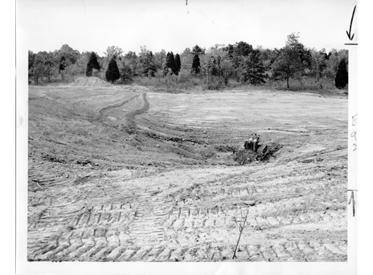
    In 2016, Nature Reserve staff set an ambitious goal to bring all 2,400 acres of the site into active management to promote native biodiversity by the year 2030. This effort will include restoring open pastures and former row crop fields, a relatively simple process. A much more challenging effort will be reclaiming 120 acres of old fields with 60+ year successional development, which is our current Wolf Run Grassland Restoration project. The 120 acre project area was initially “wasted farm ground” that had erosion gullies “where a freight train could pass without you seeing it”, according to August Beilmann, former Arboretum Director from 1941 to 1956. The entire project area was re-sculpted and smoothed by a bulldozer in 1953 and then converted to bluegrass (Poa pratensis). “Every piece of this land that looks so likely to be just right was laboriously rebuilt,” said Beilmann in a 1974 interview.

    Wolf Run Grassland Restoration project area in ca. 1945 showing open fields (light green) maintained through cattle grazing and mowing with trees occupying wet-weather streams and ditches (dark green). Photo: MBG Archives.

    Since 1958 when areas including the Wolf Run Grassland Restoration were removed from mowing and grazing, the site was encroached upon and became dominated by eastern red cedar (Juniperus virginiana), the non-native invasive shrubs Amur honeysuckle (Lonicera maackii), and border privet (Ligustrum obtusifolium), as well as slippery elm (Ulmus rubra), shingle oak (Quercus imbricaria) and ash (Fraxinus) species, the latter of which which are in severe decline due to the emerald ash borer. 

    These degraded woodlands had little native ground flora and were highly infested with non-native shrubs. Tree abundance and species composition had no historic analog. When setting ecological restoration goals for the area, staff determined that much of the site could not be managed as an open oak-hickory woodland, which would have existed at the site pre-settlement.  A new vision was needed. 

    Goals for the Wolf Run Grassland Restoration project

    • Establish a mosaic of 80 acres (~32 ha) of prairie, 15 acres (~6 ha) of savanna and 25 acres (~10 ha) of oak-hickory woodlands
    • Maximize native flora diversity and aggressively control invasive shrub species 
    • Manage with periodic, dormant-season prescribed fire 

    In 2021, Nature Reserve staff marked hundreds of native trees to retain including white, red, bur and black oaks (Quercus alba, Q. rubra, Q. macrocarpa, Q. velutina) and shagbark hickory (Carya ovata) and bitternut hickory (C. cordiformis). Drainages and wet weather streams were left with a 50 ft. (~15 m)  untreated buffer zone while a perennial creek flowing through the unit retained a 150 ft. (~46 m) untouched buffer. A logger removed unmarked trees from the area, with the commercial value of the timber offsetting the cost of the removal. Following US Fish and Wildlife Service recovery management guidelines for the Indiana bat (Myotis sodalis) — a federally endangered species — trees were only removed from November 1st to April 1st.

    Wolf Run Grassland Restoration project area pre-thinning (2021), approximately 60 years after land abandonment. Note the dark green areas are dominated by eastern red cedar (Juniperus virginiana), a native tree that rapidly colonizes abandoned or disturbed lands in the Midwest. Historically, this fire-sensitive tree species primarily occurred on rocky outcrops and bluffs that served as refugia from periodic fires that were common in the pre-European settlement landscape. Photo: ESRI
    Wolf Run Grassland Restoration project area post-thinning (2023). Photo: ESRI
    Forestry contractor equipment was used to remove most woody biomass greater than 4.5 in. (~11 cm) in diameter and left behind mostly small-diameter slash. A bulldozer was used to collect the debris into 600 piles that were subsequently burned. Photo: Mike Saxton

    The Restoration team has spent the last 9 months focusing on the removal of stumps for the project area. Stumps can be a substantial hazard for vehicles, equipment and staff safety. To seed native species and effectively manage the area for invasive species in perpetuity, the stumps must be ground down or cut flush to the ground.

    Skid loader mounted stump grinder removing stumps. Photo: M. Saxton

    Concurrent to this effort has been the site preparation step of chemically treating all of the invasive species and the disturbance driven annual vegetation that emerged post-land clearing [primarily fireweed (Erechtites hieraciifolius), mare’s tail (Erigeron canadensis), ragweed (Ambrosia artemisiifolia) and fox tail (Setaria pumila)]. This step is necessary because diverse, healthy native plant communities have not existed in these areas in more than 100 years. Consequently, there is no native seedbank to support the unassisted spontaneous recovery of native perennial herbaceous species in these highly degraded acres. 

    In areas where stumps have not been cleared, traditional equipment (tractor boom sprayers and UTV mounted spray rigs) for applying herbicide are ineffective. The Nature Reserve hired a contractor that specializes in drone-assisted aerial herbicide applications. The drone flies 12 ft. (~37 m) above vegetation and can self-navigate around trees and other hazards. The unit carries a total of 8 gallons (~30 L) and sprays approximately 3 gallons of herbicide per acre. The effective width of each pass is 25 ft. (~8 m). A single battery powers the drone, with a flight time of 7.5 minutes and a re-charge time of 6 minutes. When the herbicide tank runs out, the drone re-deploys to the fill up location, is refilled by the contractor, and then returns to where it left off. 

    Aerial drone sprayer used to eliminate undesirable vegetation. Photo: M. Saxton

    The last step after the undesirable trees have been removed, biomass/debris has been burned, the stumps have been ground and invasive species have been controlled, is the final ground preparation. Currently, in 2023, we are again smoothing out erosion gullies and clearing away the last remnants of woody debris with a bulldozer. This effort will ensure effective seed-to-soil contact when we sow native seed in January 2024 and will enhance our ability to successfully search for invasive species in the coming years by eliminating deep ruts and rills.  

    Above: Bulldozer in 1953 eliminating erosion rills in Wolf Run Grassland Restoration project area. Below: Bulldozer completing site preparation for native seed addition (2023).  Top Photo: St. Louis Globe Democrat, Bottom Photo: M. Saxton

    Native Seeding and Experimentation to promote Biodiversity Recovery 

    During the growing season of 2023, the Restoration team at the Nature Reserve has been feverishly collecting seed for this 2024 seeding effort. More than 1,100 lbs. (~500 kg) of bulk, milled seed from ~200 locally collected native tallgrass prairie and open oak-hickory woodland species will be used in the restoration planting. Additionally, these acres are enrolled in the Environmental Quality Incentives Program, EQIP – part of the Natural Resources Conservation Service, and we must purchase viability-tested seed to meet the minimum required specifications of the contract. The hand-collected seed together with the pure live seed (PLS) – percentage of viable seed in a seed lot – purchased from commercial vendors will provide us with ample species and volume of seed to effectively cover the 40 acres (~16 ha) to be planted this winter. 

    Concurrent with the preparation effort, we initiated a research study, which will help inform our work and the broader research community on plant recruitment amongst scraped soils that have been inoculated with mycorrhizal fungi and those that have not. This study includes paired species from the same genus that have different CC-values, short for coefficients of conservatism, which represents a species’ tolerance of environmental degradation, or its fidelity to intact remnant or long-restored habitats, as determined by local botanical experts. Ecologists generally expect species that are dependent on stable intact communities (higher CC-values) to be more reliant on mycorrhizae connections to establish and flourish. Species with high CC-values tend to establish poorly in restoration sites, which is one of the reasons to pursue this study. Some examples from the ten herbaceous pairs of native species include sedges (Carex bushii [CC = 4] and Carex bicknellii [CC = 10]), grasses (Sporobolus compositus [CC = 3] and Bouteloua curtipendula [CC = 7]), and forbs (Oligoneuron rigidum [CC = 5] and Oligoneuron album [CC = 9]).

    We added all 20 species at the same rate of pure live seed to provide each species an equal opportunity to establish. Initial analyses after one growing season indicate that low CC-value species germinated more successfully, producing more seedlings and greater percent cover than the high CC-value species, regardless of inoculation. We expect the addition of mycorrhizal fungi to have the greatest effects on species during the first couple of years after germination. If the mycorrhizae associate with the roots of the high-CC species more than the low-CC species, this may help them grow faster or be more resistant to future stress. Future monitoring will show us if there are long-term effects of inoculation.

    To check for updates on restoration activities and results from experimental studies, please visit our webpage.

    Barrels of hand-collected seed connected to a seed dryer, which pumps air through tubes into the barrels to eliminate mold & moisture. Photo: M. Saxton
  • In search of a lost natural community: the Ozark savanna edition

    In search of a lost natural community: the Ozark savanna edition

    Calvin Maginel is the Ecological Resource Scientist at Shaw Nature Reserve in Gray Summit, Missouri.

    Anyone hoping to join the articulate stream of Missouri articles about natural communities ought to lovingly reference Paul Nelson’s “The Terrestrial Natural Communities of Missouri” (2010). In that vein, we will start our journey with page 233, the Savanna.

    Paul differentiates savannas largely by overstory, topography, and light level characteristics. Primarily, savannas are grasslands that happen to hold little pockets, family clusters, of trees, that mosey through the swaying grass like the slowest of turtles. The natural history of these clusters is as such: a mature parent hosts numerous offspring around her perimeter that shelter her from the repeated onslaughts of prairie fires, while she in turn nurtures offspring on the lee side which will eventually replace her. They are separate from woodlands in that savannas exhibit a tree canopy of less than 30%, while woodlands can range from 30% to 90% canopy. Paul further describes the ground flora layer of savannas as being highly indicative of a prairie, holding the majority of a site’s diversity, and being strongly adapted to frequent fire.

    Of the six savanna communities Paul describes, as nostalgia blurs the typeset, two are considered S1 (critically imperiled) and four are SH, or state historic. A glass of cold water to the face: no known examples remain when something is classified as state historic. To put numbers on this, an estimated 6.5 million acres of savanna in Missouri are now represented by <1,000 recognized acres. Robin Wall Kimmerer aptly wrote: “If grief can be a doorway to love, then let us all weep for the world we are breaking apart so we can love it back to wholeness again.”

    Stylized drawings of the prairie-forest continuum, borrowed from The Tallgrass Restoration Handbook by Packard and Mutel.

    Recognizing a savanna

    As nice as it is to reminisce about and romanticize processes long devastated by European colonizers, if there are (nearly) no savannas left, then why does it matter? Well, there still is hope! While Missouri has a fair percentage of public land (11.2%), most of which has received extensive visits by ecologists throughout the years, the other 88.8% of private lands in Missouri often harbor as-yet-undescribed natural communities that may classify as savanna. In an effort to heighten awareness of these potential gems in the fire-starved hills, I offer a photo tour of a private site in southwest Washington County, near the town of Courtois, that could be described as a savanna. A few points about this site: it is currently being managed for its ground flora character, with repeated fire and herbicide, specifically to the detriment of encroaching cedars and woody re-sprouts. For 25 years prior to the current ownership, it received two fires and periodic mowing to maintain its relatively shrub-free character. Prior to that, it is assumed that this was a hay meadow, cut annually for livestock that were grazed in the valley nearby but not itself grazed. There is a rusty but strong sickle-bar mower still parked in the grass that is set up for a mule to pull, with patent dates from the 1920s.

    Since Paul begins with the overstory, so too will this tour. Anecdotal descriptions of certain areas in the Ozarks by foresters refer to “wolf trees”, trees with spreading branches that were removed from the woodlot since those individuals were considered to be exhausting resources around themselves, much as wolves were believed to be harmful predators that exhausted prey species. An example of this can be found in Photo 1, where a large white oak shows the breadth of branches characteristic of an “undesirable” wolf tree. As mentioned in the caption, the health of the lowest branches can tell something about a site’s history. Overgrazing by cattle or other domestic animals often defoliates these branches until the tree sheds them entirely, so an observation of a tree similar to this one might mean that this site was hayed but not grazed intensively.

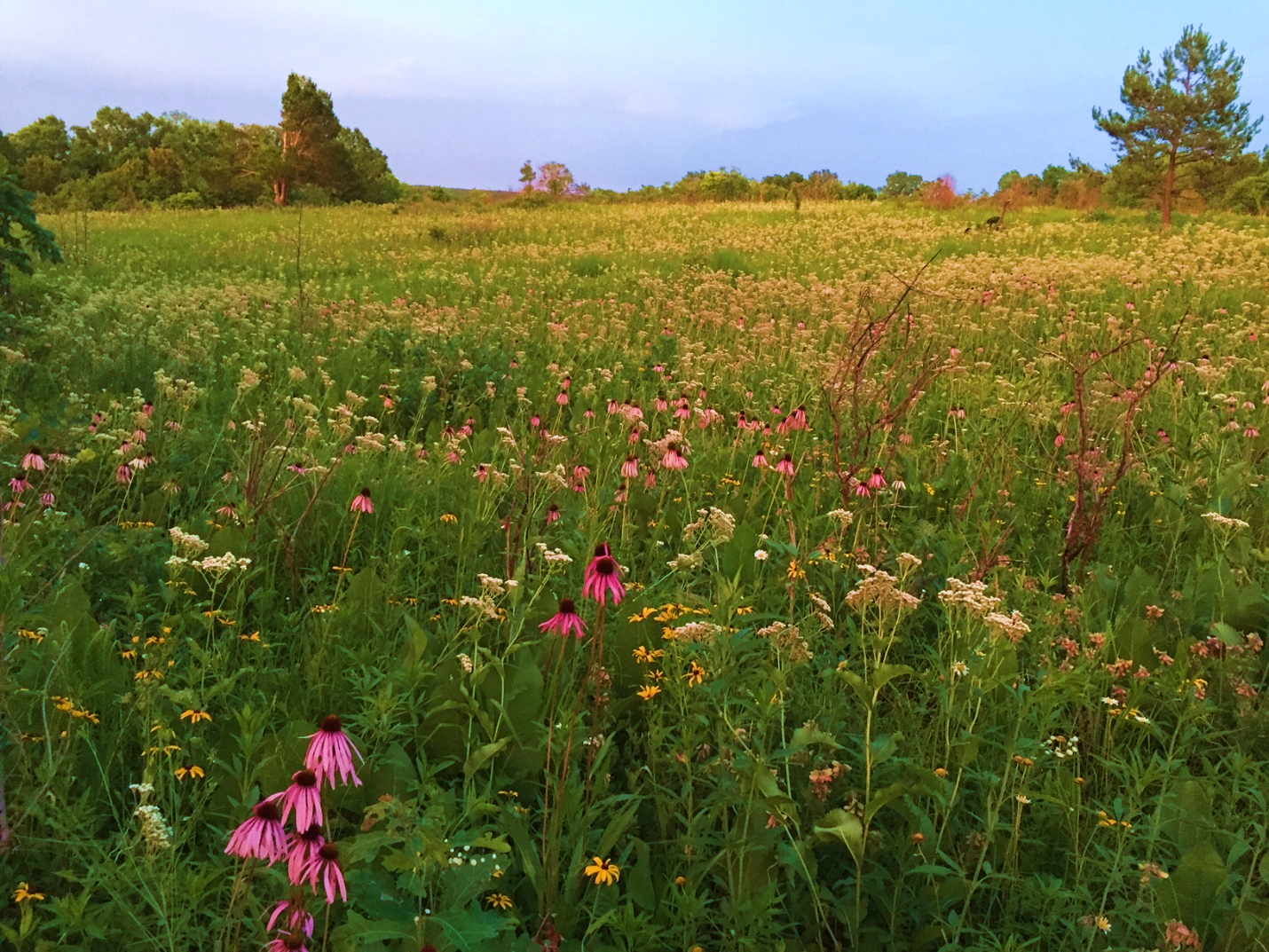
    Now that photos have been mentioned, we’ll begin the photo tour in earnest. All photos are from August 22nd, 2021, unless otherwise stated. To the right side of Photos 1, 2, and 3, you will notice a young shortleaf pine (Pinus echinata) with a wolfish future, and in Photos 2 and 3, there is a distinctive Eastern Red Cedar (Juniperus virginiana) that seems to have lost half its top. All other photos will contain at least a blurry version of those two distinctive trees, in an effort to maintain scale. Speaking of scale, the distance between the white oak wolf tree and the red cedar is a little over 250 feet (76 meters). Photos 2 and 3, of almost the same area at different phenologies, hold the first real hope of a savanna classification. The structure is distinctively grass- and forb-dominated. While clearly the floral display is greater during June, this is not unexpected in an intact prairie system where suitable micro-habitats are dominated by the best-adapted competitors for those micro-habitats. For example, the glade coneflower in Photo 3 is distributed between the foreground of the photo and the base of the pine tree, but seems to decrease in abundance towards the red cedar in the upper left of the photo. Presumably, soil or other characteristics make the former area highly suitable for glade coneflower, despite the fact that no bedrock or other glade indicators occur in those areas. That said, it stands to reason that glade coneflower, currently relatively restricted to glade communities, must have had a mechanism to lay claim to those communities. Possibly this species was historically as ubiquitous in Ozark savannas and prairies as it currently is in glades.

    Photo 1. Forgive the valiantly bolting hickory grubs and mowed path, but this white oak (Quercus alba) exemplifies the spreading nature of a relatively open-grown specimen. Note how the lower branches actually touch the warm season grasses: despite 5 recent years of annual dormant season fire, they are not set back. In fact, one telltale of current or historical colonizer-style grazing is that these perpetually-stretching side limbs are defoliated until they succumb and die. Trees with this character can tell a lot about a site’s history.
    Photo 2. With the same white oak as in Photo 1 to the left of the frame, this photo shows the vegetative structure of the site. You will notice a handful of woody re-sprout clumps, but this area is largely dominated by warm season grasses and prairie forbs.
    Photo 3. June 14, 2016 is the date on this photo. Note the profusion of wild quinine (Parthenium integrifolium) and glade coneflower (Echinacea simulata), the latter of which is commonly identified by its yellow pollen. The more westerly species with white pollen, E. pallida, does not occur on this site.

    In addition to the striking summer floral display in Photo 3, there are distinct waves of blooms throughout the season. Each species, present in profusion in its preferred micro-habitat and scattered elsewhere, blooms en masse and then fades into the background, letting another take the stage like a carefully-choreographed dance.

    At this point, you may be noticing that the common names for many of the plants listed in the photo captions refer to a habitat (eg “glade” coneflower, “upland” white goldenrod, “prairie” coreopsis). This name-relation to a community can serve to help with identifying that community, but the overall assemblage of species tells a stronger story. When you consistently encounter species that occur within multiple habitats (Ozark woodlands, glades, and/or prairies), which is true for most of the species shown in these photos, it may be a telltale sign of the missing connection between all of those communities. Similar to the previously mentioned glade coneflower, both downy gentian and the upland white goldenrod are commonly found in glades and open woodlands. They tend to fall out in areas with >60% shade. Almost all of these species are considered highly conservative; species that we expect to maintain high fidelity to intact ecosystems. Missouri is one of the states that maintains a coefficient of conservatism list, with values ranging from 0 to 10, where 9-10s are virtually only found in the highest quality habitats. For example, the downy gentian, white upland goldenrod, savanna blazing star, and southern prairie aster are all c=9 species. Most of the grasses are 4 or 5, as well as the prairie dock, prairie blazing star, and Canada lousewort. When visiting a natural community, generally the more intact, remnant sites boast a bell curve of c-values, with the peak being a good diversity of c = 4-6 species. The distinctive composition at this site, with conservative prairie and glade species present (yet located deep in the Ozarks in an area not considered historic prairie), triggers the savanna vibe.

    Photo 4. Savanna blazing star (Liatris scariosa var. nieuwlandii), wild quinine, big bluestem, and ashy sunflower. Savanna blazing star is currently listed as a species of conservation concern in Missouri.
    Photo 5. Southern prairie aster (Eurybia hemispherica, old name Aster paludosus), forms a colony with leaves reminiscent of a graminoid until it blooms with striking purple discs.

    An additional, striking character of this site is the height of the vegetation (Photos 6 and 7). In particular, Photo 6 includes a species called ashy sunflower (Helianthus mollis). Various botanists and restorationists have used disparaging terms for this species, even the socially problematic term “thuggish,” since this species tends to form thick 2-4 foot tall monocultures to the detriment of other species. Surprisingly, the ashy sunflower at this site is a whopping 0.5 – 1 foot high and comfortably interwoven with other species. The matrix grasses, consisting of mostly of big bluestem (Andropogon gerardii), little bluestem (Schizachyrium scoparium), prairie dropseed (Sporobolus heterolepis), and Indian grass (Sorghastrum nutans) are consistently knee-high or shorter, barring their flowering stems of around 5 feet. In many prairie reconstructions, the big bluestem and Indian grass commonly attain heights of more than 9 feet and encountering each clump of bunchgrass is like climbing up a small mima mound. Here, the grass ramets have presumably reached old age and no longer exhibit the mounding character. Many ecologists attribute the presence of hemi-parasitic species like Canada lousewort (Pedicularis canadensis), scarlet paintbrush (Castilleja coccinea), or blue hearts (c=10!, Buchnera americana) to decreased robustness of warm season grasses. All three of these hemiparasitic species are present at this site, yet the truth is that the science of ecology is still learning about what actually makes remnant sites look consistently different than reconstructed sites. Is it nutrient limitation, due to all niches being occupied in remnants? Maybe it’s mycorrhizal associations determining community composition and structure, since Arbuscular Mycorrhizal Fungi have been shown to strongly affect plant communities. What about beneficial or pathogenic bacteria, or soil structure, maybe parent material, or surely it’s the site’s aspect and moisture profiles? The obvious answer is that it’s a combination, and that we have much to learn about our natural communities. The quote by J. K. Rowling, “Understanding is the first step to acceptance, and only with acceptance can there be recovery,” might as easily have been about natural communities as it was directed at Harry Potter’s life.

    Photo 6. Upland white goldenrod/prairie goldenrod (Oligoneuron album) blooms amongst two Silphium species, prairie coreopsis (Coreopsis palmata), and well-mannered ashy sunflower (Helianthus mollis) stems. Rarely is the term well-mannered used in conjunction with ashy sunflower.
    Photo 7. Downy gentian (Gentiana puberulenta) looking disheveled prior to its glorious frost-triggered blooms, amidst prairie dock, prairie blazing star, and a grass/sedge matrix. A dominant sedge species here is few-flowered nut rush (Scleria pauciflora).

    The last point regarding vegetative species groups are those considered woodland species. Just like in prairies and glades, there are a handful of woodland indicator species that assist with identification of the natural community we call a woodland in Missouri. As a reminder, woodlands have a canopy cover of >30%, all the way up to 90% cover, yet have an open mid-story maintained most commonly with frequent fire. Some characteristic species present at this site that are considered common woodland indicators include deerberry (Vaccinium stamineum), Samson’s snakeroot (Orbexilum pedunculatum), and stiff aster (Ionactis lineariifolia). The last species is especially striking, as botanists and plant geeks commonly observe it in acidic, poor-nutrient woodlands or power line rights-of-way. Yet keep in mind that glade coneflower, a known calciphile, is hanging out with the stiff aster. Whatever processes are allowing this site to host such a mish-mash of Ozark woodland, glade, and prairie flora, it seems to support the understudied idea that there really was a thriving prairie-forest ecotone amongst these aged hills.

    Photo 8. Prairie willow in the foreground left (Salix humilis), vying for growing space with prairie dock (Silphium terebinthinaceum), tall tickseed (Coreopsis tripteris), little-leaf tick trefoil (Desmodium ciliare), and others.

    Wrapping Up

    As outlined above, there are few to no known savannas left in Missouri. While many agencies are trying valiantly to re-create open or closed woodlands, the sawdust of Missouri’s logging culture weighs heavily on our boots and generally there are fewer restoration practitioners aiming for savannas and their lack of timber products. The Nature Conservancy comes to mind, but the majority of their sites classify as true prairie, except maybe Bennett Spring Savanna. That site, like Ha Ha Tonka State Park, tends to maintain characteristics more similar to open woodland, but has lovely intact ground flora with a solid assemblage of prairie species. The critical missing piece is that for most natural community restorations, we have a goal in mind, dictated and informed by multiple examples of that community. With savannas and the lack of high-quality examples, we are left with a great deal more speculation. The hope mentioned in the beginning comes into play with each of you. There is a plethora of private lands that are largely inaccessible to state and federal biologists. If you get a chance to visit a friend’s farm, do so with a thought to some of the characteristics described above. Citizen science really does work, and maybe the next branch of citizen science is natural community identification! As Rachel Carson said, “The more clearly we can focus our attention on the wonders and realities of the universe about us, the less taste we shall have for destruction.”